Hau Giang Province: Mekong Delta Waterways and Authentic Markets
Hau Giang province in the Mekong Delta is defined by its intricate canal network, rice paddies, and vibrant local markets. Less touristed than neighbors like Can Tho, it offers an authentic glimpse into the rhythm of delta life.

Hau Giang province sits in the heart of Vietnam's Mekong Delta (메콩 델타 / 湄公河三角洲 / メコンデルタ), overshadowed by its larger neighbor Can Tho but holding its own with distinct charm. The province's identity pivoted in 2004 when Can Tho city was elevated to municipality status, and the remaining rural and waterway-dependent areas became Hau Giang as we know it today.
Geography and Waterways
The province is defined by low-lying terrain and an extensive network of rivers and canals integral to daily life and transport. The Hau River (Bassac River), a major Mekong distributary, anchors the system. Boats and ferries are common—sometimes more reliable than roads on the waterlogged landscape.
National Highway 61 spans approximately 120 kilometers through the province, linking Hau Giang to Can Tho (껀터 / 芹苴 / カントー) Municipality and onward to Ho Chi Minh City. But waterways are the real arteries here. If you're driving, the section of Highway 61 through Cai Tac town market offers a genuine snapshot of local commerce and daily rhythm—farmers, vendors, and the smell of produce and diesel fuel.
Key Towns and Administrative Heart
Vi Thanh is the provincial capital and administrative hub. It's modest compared to Can Tho or Ho Chi Minh City (호치민시 / 胡志明市 / ホーチミン市), but that's the point. The city center features a clock tower and the Chuong Thien Victory Monument in Ward 5. These aren't Instagram spots—they're local landmarks that mark civic identity.
Nga Bay, another provincial city, is known for its floating markets and role as a waterway junction. Both towns reflect the slower pace and agricultural focus that defines Hau Giang.
Agriculture and Local Economy
Rice cultivation, fruit orchards, and aquaculture are the backbone. The Mekong Delta's fertile alluvial soils support large-scale farming, and the markets overflow with fresh produce. You'll find "banh mi" vendors stacked with tomatoes and herbs pulled from local fields. The province has established a 902-hectare industrial zone, signaling a gradual economic diversification, but agriculture remains the dominant force.
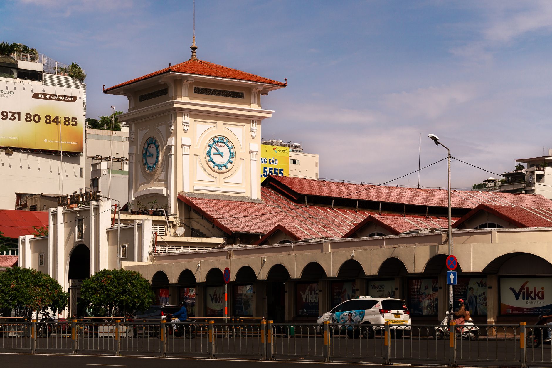
Photo by Thien Phuoc Phuong on Pexels
Markets and Regional Cuisine
Food here is hyper-local and seasonal. Nga Bay's floating markets are worth the early start—by 6 a.m., vendors are selling everything from river fish to tropical fruit. The pace is unhurried and distinctly non-touristy.
Regional dishes reflect the delta's waterways: fresh river fish, shrimp from aquaculture ponds, and rice-based staples. Street food is inexpensive (most meals under 50,000 VND) and authentic—not plated for cameras. "[Com tam](/posts/com-tam-saigon (사이공 / 西贡 / サイゴン)-broken-rice)" (broken rice) with grilled fish is a morning standard.
Exploring by Water and Road
Visitors can take boat trips along canals, exploring the landscape from water level and seeing how communities live along the waterways. The Lung Ngoc Hoang Nature Reserve offers wetland ecosystems and birdwatching for those with patience and decent binoculars.
Transport is straightforward: buses from Can Tho or Ho Chi Minh (호치민 / 胡志明 / ホーチミン) City run regularly to Vi Thanh and other towns. Once there, motorbike rental (around 100,000-150,000 VND per day) is practical; canal-side villages are often better explored on two wheels than by car.
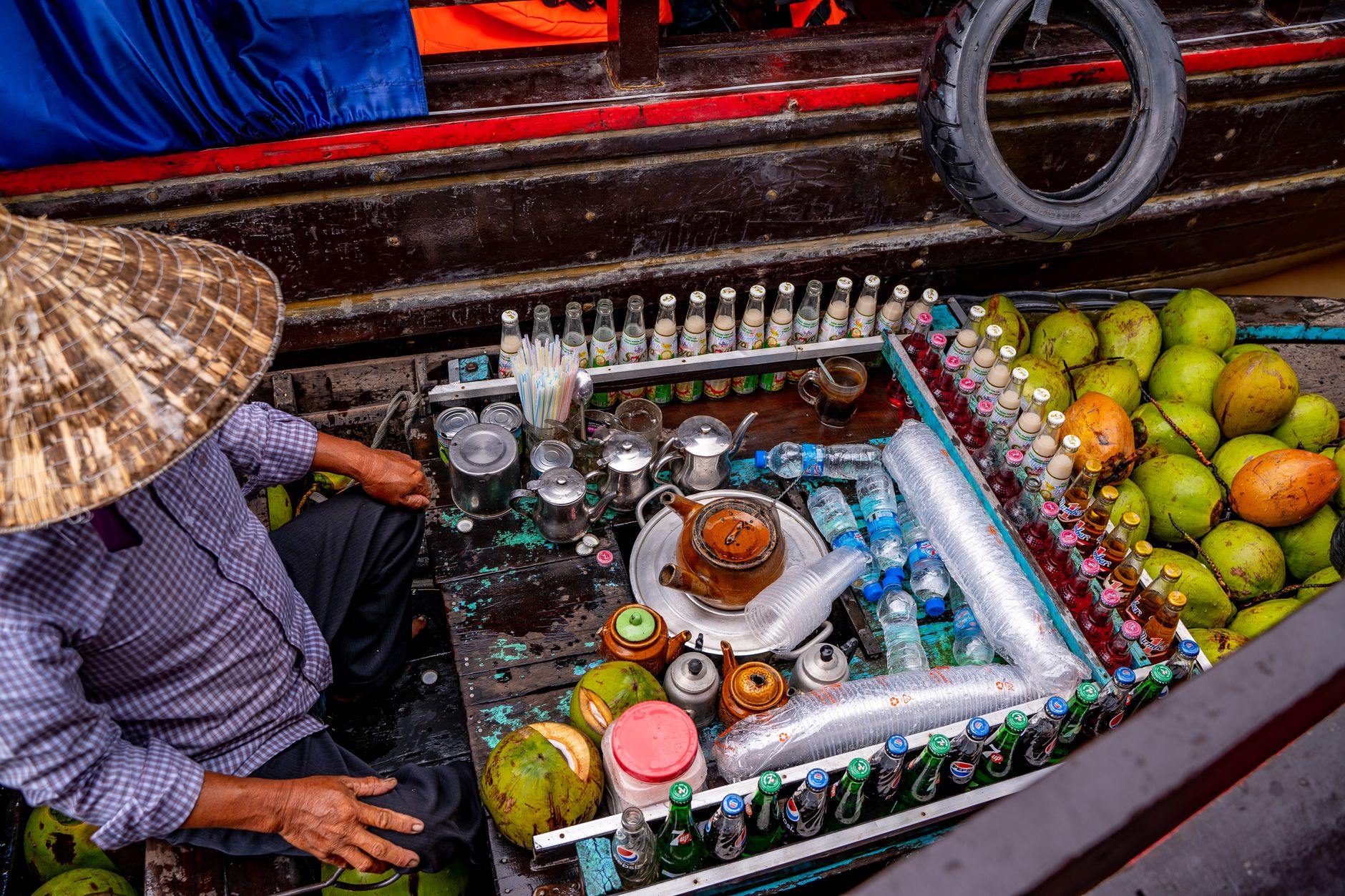
Photo by Vietnam Tri Duong Photographer on Pexels
Climate and Timing
Hau Giang's low elevation and canal-dependent infrastructure make it vulnerable to flooding during monsoon season (May–October). The driest, most pleasant months are November through February. Temperatures are warm year-round (25-35°C), and humidity is high.
Why Visit
Hau Giang won't satisfy travelers hunting for colonial architecture or white-sand beaches. It's for people interested in how most of Vietnam's south actually lives—rural, water-bound, agricultural, and largely unglamorous. The pace is deliberate. The markets are real. The food is fresh and cheap. If you've spent time in Saigon or Can Tho and want to see the delta without the tourist infrastructure, Hau Giang is the answer.
The province's ongoing environmental challenges—sea-level rise and land subsidence threaten low-lying areas—add a layer of urgency to visiting now, to witness the traditional way of life while it persists in current form.
Going to Vietnam? Eat and travel smarter.
Monthly: new dishes, off-the-beaten-path destinations, and itineraries — straight to your inbox. No spam. Unsubscribe anytime.
Join 0 expats. (We just launched.)
More from vi-thanh
Other articles covering this city.

Best Chao Ca Loc in Can Tho: Where Locals Send You
Chao ca loc—rice porridge with snakehead fish—is a Can Tho breakfast ritual. Here's where locals actually eat it, what it costs, and why this city does it better than anywhere else.

Where to Stay in Can Tho: Ninh Kieu, Cai Rang, or Orchards
Can Tho's three main neighborhoods offer different angles on Mekong Delta life. Here's how to pick based on your priorities and budget.

Where to Stay in the Mekong Delta: Can Tho vs Ben Tre vs Chau Doc
Can Tho offers the most amenities, Ben Tre delivers homestay immersion on coconut farms, and Chau Doc gives you the border-town edge. Here's how to pick based on budget and vibe.
More from Southern Vietnam
Other articles covering the same region.

Landmark 81 Saigon: Observation Deck, Ice Rink, and Getting There from District 1
Landmark 81 is Vietnam's tallest building and Saigon's most visible skyline anchor. Here's what's actually inside and whether it's worth the trip.

Bitexco Financial Tower: Skydeck, Helipad Bar, and Whether the Ticket Is Worth It
Saigon's most recognizable skyscraper charges 250,000 VND to ride up to the 49th floor — here's what you actually see, and whether you should bother.

Notre Dame Cathedral Saigon: French Colonial Centerpiece in the Heart of HCMC
Saigon's Notre Dame Cathedral has been wrapped in scaffolding for years, but the square in front of it remains one of the best starting points for a colonial-era walking tour of District 1.
More in Destinations
More articles from the same category.

Paradise Cave, Quang Binh: The 31km Marble Cave That Beats Phong Nha for Photographers
Paradise Cave runs 31km through Quang Binh's karst and delivers the kind of cathedral-scale formations that Phong Nha's boat tour simply can't match. Here's how to see it properly.

Son Doong Cave: What the $3,000 Oxalis Expedition Actually Includes
Son Doong is the world's largest cave and only one operator is legally allowed to take you inside. Here is what the permit-only expedition covers and whether it is worth it.

Phong Nha Cave: Wet Cave, Dry Cave, and How to Choose
Phong Nha has two main caves worth your time — one you reach by river boat, one on foot. Here's how to pick, what each costs, and when to go.

Hoi An Lantern Festival: Full Moon Nights and How to Plan Around Them
Once a month, Hoi An cuts the electricity and lights the Ancient Town with silk lanterns. Here's what actually happens and how to not spend the evening stuck in a crowd.

Japanese Bridge Hoi An: 400 Years of History, a Restoration Row, and How to See It Right
Hoi An's Japanese Bridge has anchored the Ancient Town for four centuries. Here's what to know about its origins, the restoration that divided locals, and when to visit.

Hoi An Old Town Walking Guide: Yellow Walls, Lantern Alleys, and the Japanese Bridge
A street-level route through Hoi An's UNESCO core — old merchant houses, assembly halls, the famous Japanese Bridge, and when to walk each stretch for the best light.
Comments
Loading…