Ninh Thuan Province: Cham Culture, Arid Coasts, and Hidden Temples
Ninh Thuan's dry climate and Cham villages make it one of Vietnam's most distinctive provinces. Explore arid mountain forests, pottery crafts, and centuries-old temples in the South Central Coast.

Ninh Thuan is not for everyone—it's Vietnam (베트남 / 越南 / ベトナム)'s driest province, with some inland areas getting less than 800 mm of rain a year. But that harsh landscape is exactly why it's worth visiting. The province sits on the South Central Coast between Khanh Hoa and Binh Thuan, and it's home to the Cham people, an ethnic Muslim minority whose heritage runs deeper here than anywhere else in the country.
Why Ninh Thuan Feels Different
The first thing you notice is the light. Mountains rise straight from the coast—Nui Chua peaks at 1,040 meters on the northeast edge—and the arid climate strips away the lush greenery you see in wetter regions. Yet 55.7% of Ninh Thuan is still forested, most of it protected inside Nui Chua National Park and Phuoc Binh National Park. The forests hug the northeast coast and the western highlands. The Dinh River runs through the lowlands and Phan Rang, the provincial capital, but it's not a major waterway.
Population here is modest: about 565,700 people as of the latest count, with the Kinh majority living alongside significant Cham and Raglai communities. The province has been part of Vietnam's administrative map since 1901, when it was called Phan Rang province. It's been merged, renamed, and split multiple times—most recently regaining separate status in 1991.
Cham Villages and Crafts
The Cham are the real draw. Many live near Phan Rang and in outlying districts, maintaining their own villages and traditions. Bau Truc (Cham: Hamu Craok) in Ninh Phuoc District is the most famous—it's a pottery village where Cham potters work clay the way their ancestors did, without a pottery wheel. You can walk through and watch them hand-shape vessels using coiling and paddling techniques. The pots are rough, functional, and beautiful.
My Nghiep (Cham: Caklaing), also in Ninh Phuoc, is known for traditional "brocade" weaving—hand-loomed silk with geometric patterns. Both villages are within easy reach of Phan Rang and offer a glimpse of craft work that's been continuous for centuries, not revived for tourists.
Other notable Cham villages include Ram Van Lam and Aia Li-u in Thuan Nam District; Cang in Ninh Son District; Tabeng in Phan Rang proper; Pamblap Klak in Ninh Hai District; and Bal Riya in Thuan Bac District. Each keeps its dual name—Cham alongside Vietnamese—and each has its own rhythm of life.
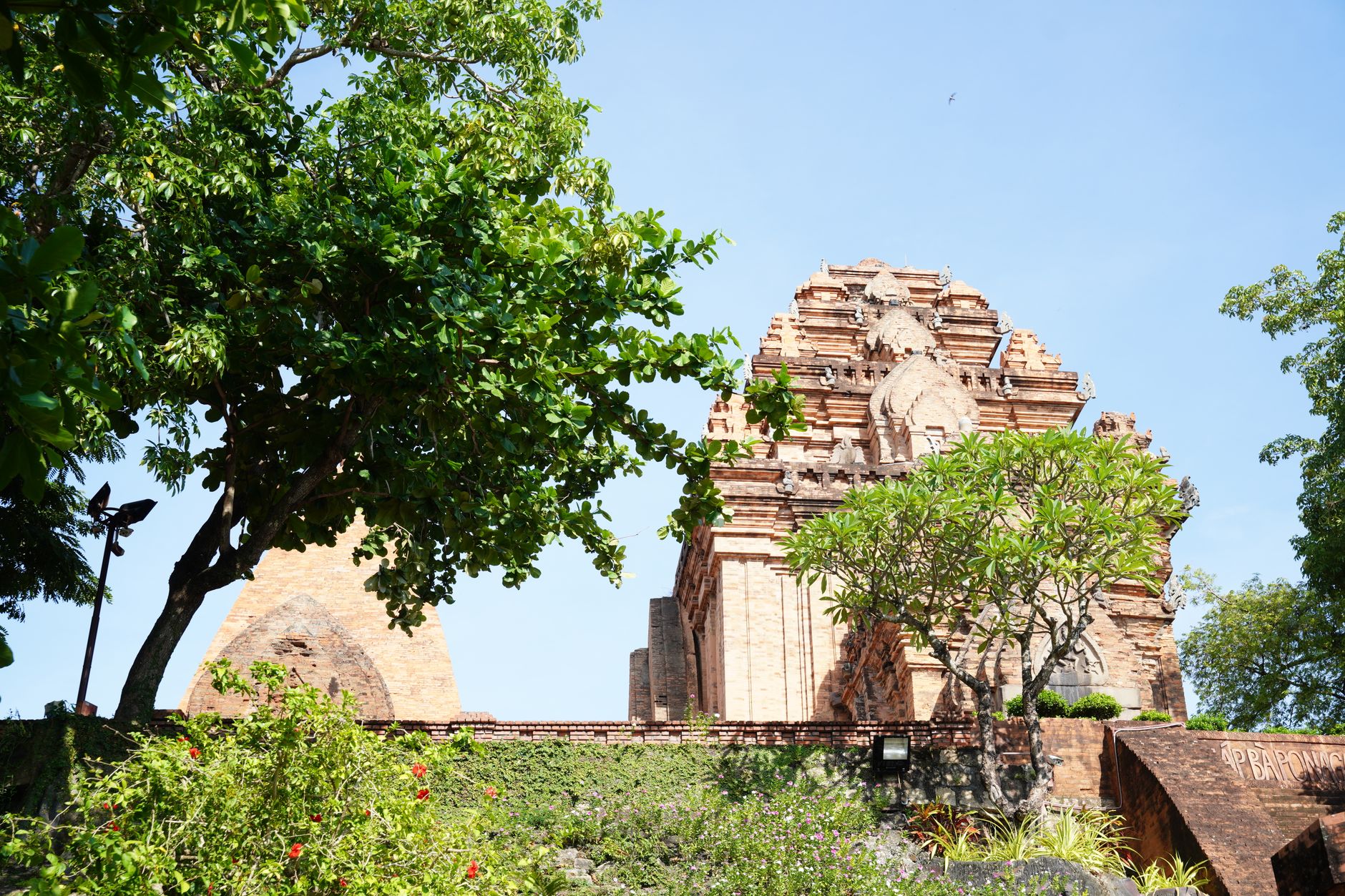
Photo by NGUYỄN THÀNH NHƠN on Pexels
Po Klong Garai and Cham Temples
Near Phan Rang, the Po Klong Garai temples are the physical heart of Cham religious practice in Ninh Thuan. These brick towers, dedicated to Shiva, were built over centuries and remain working shrines. The architecture is distinctive—octagonal or square bases with false doors, intricate terracotta decoration—and the setting, on a low hill overlooking rice fields, feels both remote and inhabited. This is not a museum; it's a place where Cham Hindus (about 40,695 in the province, the highest concentration in Vietnam) still worship.
Landscape and National Parks
If you're drawn to empty coasts and dry mountains, Vinh Hy Bay offers both—it's scenic and relatively quiet, though high-end resorts like Amanoi have been built there in recent years. The bay has coral reefs and clear water; diving and snorkeling are possible.
Nui Chua National Park is the larger conservation area, protecting both forest and coastal ecosystems. Hiking trails exist but are not heavily developed. Phuoc Binh National Park covers the western uplands. Both are real nature reserves, not theme parks.
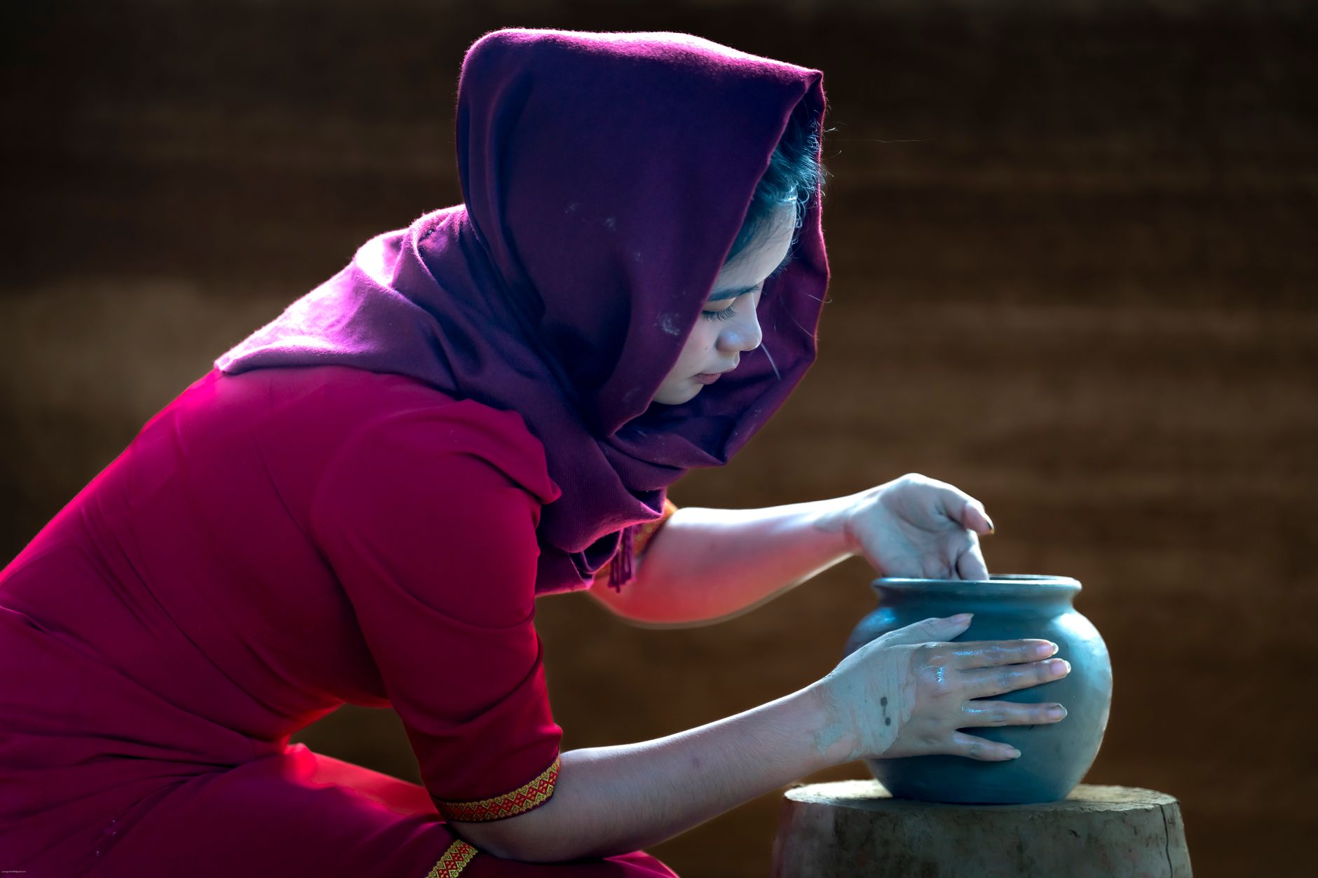
Photo by Quang Nguyen Vinh on Pexels
Food and Economy
Ninh Thuan's economy is agricultural and fishing-based. Rice dominates (33,400 hectares) but tobacco is the cash crop—1,300 hectares of it, yielding about 3,300 tons annually, roughly 10% of Vietnam's tobacco supply. You'll also see cashew nuts, maize, peanuts, and coconuts. Fishing has boomed, growing at 11.7% annually, faster than any other sector.
Local dishes reflect both Kinh and Cham traditions. Rice and fish are staples; you'll find good seafood in Phan Rang. Cham cuisine includes curried fish and coconut-based curries, if you know where to look—not as visible in restaurants as Kinh food, but available in village homes and a few dedicated spots.
Practicalities
Phan Rang–Thap Cham is the hub. Most visitors arrive by bus or drive from nearby provinces. The provincial population is 565,700; the city itself is much smaller and quiet compared to Nha Trang (냐짱 / 芽庄 / ニャチャン) (Khanh Hoa) to the north. Hotels are basic and cheap. Roads to Bau Truc, My Nghiep, and Po Klong Garai are paved and navigable by motorbike or car.
The best time to visit is October to April, when the heat is less punishing. May to September is hot and dry—some might find it oppressive.
Ninh Thuan is not Phu Quoc or Nha Trang. It won't overwhelm you with beaches or nightlife. What it offers is quietness, genuine Cham culture, arid beauty, and the sense that you've stepped into a region most tourists skip. That's the point.
Going to Vietnam? Eat and travel smarter.
Monthly: new dishes, off-the-beaten-path destinations, and itineraries — straight to your inbox. No spam. Unsubscribe anytime.
Join 0 expats. (We just launched.)
More from Southern Vietnam
Other articles covering the same region.

Landmark 81 Saigon: Observation Deck, Ice Rink, and Getting There from District 1
Landmark 81 is Vietnam's tallest building and Saigon's most visible skyline anchor. Here's what's actually inside and whether it's worth the trip.

Bitexco Financial Tower: Skydeck, Helipad Bar, and Whether the Ticket Is Worth It
Saigon's most recognizable skyscraper charges 250,000 VND to ride up to the 49th floor — here's what you actually see, and whether you should bother.

Notre Dame Cathedral Saigon: French Colonial Centerpiece in the Heart of HCMC
Saigon's Notre Dame Cathedral has been wrapped in scaffolding for years, but the square in front of it remains one of the best starting points for a colonial-era walking tour of District 1.
More in Destinations
More articles from the same category.

Paradise Cave, Quang Binh: The 31km Marble Cave That Beats Phong Nha for Photographers
Paradise Cave runs 31km through Quang Binh's karst and delivers the kind of cathedral-scale formations that Phong Nha's boat tour simply can't match. Here's how to see it properly.

Son Doong Cave: What the $3,000 Oxalis Expedition Actually Includes
Son Doong is the world's largest cave and only one operator is legally allowed to take you inside. Here is what the permit-only expedition covers and whether it is worth it.

Phong Nha Cave: Wet Cave, Dry Cave, and How to Choose
Phong Nha has two main caves worth your time — one you reach by river boat, one on foot. Here's how to pick, what each costs, and when to go.

Hoi An Lantern Festival: Full Moon Nights and How to Plan Around Them
Once a month, Hoi An cuts the electricity and lights the Ancient Town with silk lanterns. Here's what actually happens and how to not spend the evening stuck in a crowd.

Japanese Bridge Hoi An: 400 Years of History, a Restoration Row, and How to See It Right
Hoi An's Japanese Bridge has anchored the Ancient Town for four centuries. Here's what to know about its origins, the restoration that divided locals, and when to visit.

Hoi An Old Town Walking Guide: Yellow Walls, Lantern Alleys, and the Japanese Bridge
A street-level route through Hoi An's UNESCO core — old merchant houses, assembly halls, the famous Japanese Bridge, and when to walk each stretch for the best light.
Comments
Loading…