Khanh Hoa Province: Nha Trang, Cam Ranh, and the South Central Coast
Khanh Hoa spans Vietnam's south-central coast with Nha Trang as its beating heart. Diverse terrain, thriving Cham villages, and a major international airport make it a gateway to beaches, mountains, and regional culture.

Khanh Hoa is a coastal province in south-central Vietnam, bordered by Dak Lak to the northwest, Lam Dong to the southwest, and the South China Sea to the east. In June 2025, it merged with Ninh Thuan, expanding to 11,911 km² and a population of 1.88 million people. For travelers, the province is synonymous with Nha Trang (냐짱 / 芽庄 / ニャチャン)'s beaches and Cam Ranh's international access—but the real depth lies inland and in lesser-known communities.
The Landscape
Khanh Hoa's terrain swings between extremes. Vonh Phu Mountain, the highest point at 2,051 meters, towers on the Dak Lak border and anchors the western rim. Lowland plains sprawl around Ninh Hoa to the north, where agriculture still dominates. More than half the province is forested—a fact that shapes both ecology and local livelihoods. The coastline offers the obvious draw, but trekking into the interior reveals limestone karsts and mountain streams that rival the beaches.
Nha Trang and Urban Life
Nha Trang is the second-largest industrial hub in the region, and it shows—not in a grim way, but in density and forward momentum. As of 2007, Khanh Hoa's urban population stood at 466,500 (40.7% of the total), the highest urbanization rate on the south-central coast at that time. The average growth rate hovered around 1.26% annually, though urban areas grew faster at 2.24%, which tells you where investment and migration are flowing.
The city itself is the draw for most visitors: seafood restaurants clustered along Tran Phu Boulevard, beach vendors, nightlife, and a working port that never sleeps. Cam Ranh International Airport, in the southern part of the province, is Vietnam (베트남 / 越南 / ベトナム)'s fourth busiest and the primary entry point for foreign tourists flying into the region.

Photo by Quang Nguyen Vinh on Pexels
Cham Culture and Heritage
What sets Khanh Hoa apart is the presence of Cham communities with deep roots. Multiple villages retain traditional Cham names and practice distinct customs—a living thread of a pre-Vietnamese civilization still visible on modern maps. Bau Truc, My Nghiep, Chung My, Huu Duc, and Phuot The are some of the better-known settlements. These villages are scattered across Thuan Nam, Ninh Phuoc, Ninh Son, Phan Rang–Thap Cham, Ninh Hai, and Thuan Bac districts.
Visiting a Cham village offers a different pace from Nha Trang tourism. You'll encounter traditional architecture, artisan crafts, and cuisine that diverges from ethnic-Vietnamese norms. It's accessible but still off most tourist radars.
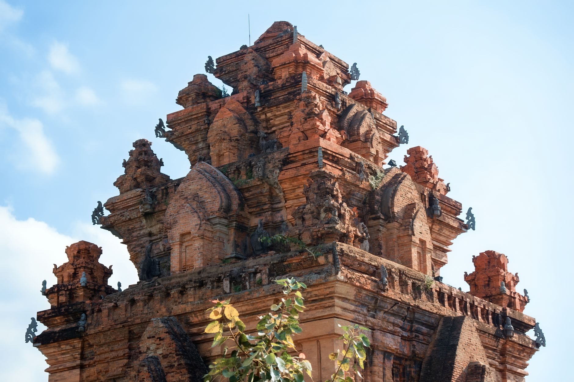
Photo by ㅤ quang vinh ㅤ on Pexels
Economy: Fishing, Farming, and Food
Khanh Hoa's economy is dominated by fishing and industrial food production. In 2007, the province exported $503.3 million in goods (mainly seafood) against $222.5 million in imports—a healthy trade surplus. Rice output that year was 188,500 tons, but sugarcane ($738,200 tons, 4.25% of Vietnam's national total) and cashew nuts (5,238 tons) are the real agricultural stories. Fish, however, outweighs all agriculture combined—shrimp farms and fish sauce factories are ubiquitous.
Food processing plants, beverage production, and textile mills dot the province. The historic Russian naval base at Cam Ranh, though reduced in scale, still anchors roughly 30 factories. For food lovers, this infrastructure means Khanh Hoa supplies much of Vietnam's seafood and shrimp paste that finds its way into restaurants nationwide.
Getting There and Moving Around
Khanh Hoa sits squarely on Vietnam's main north-south artery. National Road 1 and the North–South Railway both cut through the province, making it a natural waypoint between Hanoi and Ho Chi Minh City. Cam Ranh International Airport offers direct flights from Bangkok, Seoul, Singapore, and other regional hubs—critical for tourists who don't want a 12-hour bus ride. Once you arrive, local buses and motorbike taxis get you to Nha Trang (about 2 hours from Cam Ranh) or inland towns like Phan Rang–Thap Cham.
The province's position on Vietnam's coast and its connection to key transport arteries make it logistically simple to visit—a quality often overlooked when travel guides fixate on "off the beaten path." Sometimes being on the main road is the point.
Going to Vietnam? Eat and travel smarter.
Monthly: new dishes, off-the-beaten-path destinations, and itineraries — straight to your inbox. No spam. Unsubscribe anytime.
Join 0 expats. (We just launched.)
More from Nha Trang
Other articles covering this city.

Best Bun Sua in Nha Trang: Where Locals Line Up
Nha Trang's version of "bun sua" (broken rice with grilled pork) differs from the southern classic — here it's lighter, fresher, with seafood twists. We found the spots locals actually eat at.
Best Banh Can in Nha Trang: Where Locals Eat
Nha Trang's version of "banh can" is lighter and sweeter than the northern style. Here are the spots where locals actually go, prices, and how to order.
Best Nem Nuong in Nha Trang: Where Locals Actually Eat
Nha Trang's nem nuong is leaner, smokier, and more herb-forward than what you'll find inland. Here's where locals queue up for the real thing.
More from Central Vietnam
Other articles covering the same region.

Paradise Cave, Quang Binh: The 31km Marble Cave That Beats Phong Nha for Photographers
Paradise Cave runs 31km through Quang Binh's karst and delivers the kind of cathedral-scale formations that Phong Nha's boat tour simply can't match. Here's how to see it properly.

Son Doong Cave: What the $3,000 Oxalis Expedition Actually Includes
Son Doong is the world's largest cave and only one operator is legally allowed to take you inside. Here is what the permit-only expedition covers and whether it is worth it.

Phong Nha Cave: Wet Cave, Dry Cave, and How to Choose
Phong Nha has two main caves worth your time — one you reach by river boat, one on foot. Here's how to pick, what each costs, and when to go.
More in Destinations
More articles from the same category.

Landmark 81 Saigon: Observation Deck, Ice Rink, and Getting There from District 1
Landmark 81 is Vietnam's tallest building and Saigon's most visible skyline anchor. Here's what's actually inside and whether it's worth the trip.

Bitexco Financial Tower: Skydeck, Helipad Bar, and Whether the Ticket Is Worth It
Saigon's most recognizable skyscraper charges 250,000 VND to ride up to the 49th floor — here's what you actually see, and whether you should bother.

Notre Dame Cathedral Saigon: French Colonial Centerpiece in the Heart of HCMC
Saigon's Notre Dame Cathedral has been wrapped in scaffolding for years, but the square in front of it remains one of the best starting points for a colonial-era walking tour of District 1.

Hoi An Lantern Festival: Full Moon Nights and How to Plan Around Them
Once a month, Hoi An cuts the electricity and lights the Ancient Town with silk lanterns. Here's what actually happens and how to not spend the evening stuck in a crowd.

Japanese Bridge Hoi An: 400 Years of History, a Restoration Row, and How to See It Right
Hoi An's Japanese Bridge has anchored the Ancient Town for four centuries. Here's what to know about its origins, the restoration that divided locals, and when to visit.

Hoi An Old Town Walking Guide: Yellow Walls, Lantern Alleys, and the Japanese Bridge
A street-level route through Hoi An's UNESCO core — old merchant houses, assembly halls, the famous Japanese Bridge, and when to walk each stretch for the best light.
Comments
Loading…