Tra Vinh: Mekong Delta province with deep Khmer roots
Tra Vinh province, merged with Vinh Long in 2025, sits in the southern Mekong Delta with a distinctive population—nearly a third Khmer Krom, plus one of Vietnam's largest ethnic Chinese communities. Pagodas, canals, and a quiet rhythm define the region.

Tra Vinh is a former province in the Mekong Delta (메콩 델타 / 湄公河三角洲 / メコンデルタ) that officially merged with Vinh Long province on June 12, 2025. For decades, it was known for its ethnic diversity, significant Khmer Buddhist presence, and the quiet rhythms of delta life. Even as it transitions administratively, the cultural and geographic character of the region remains distinct.
Name and Etymology
The name Tra Vinh comes from the Khmer "Preah Trapeang," meaning "Sacred Pond" or "Buddha's Pond." Vietnamese speakers rendered this as Tra Vang, then Tra Vinh over time. The area was sparsely settled until King Minh Mang formally established it as Lac Hoa district in 1825, using variants like cha-vang or cha-vinh. Throughout the 20th century, the province's name shifted repeatedly—from Vinh Tra (1951), to Vinh Binh (1957), to Cuu Long (1976), back to Tra Vinh (1992)—reflecting larger administrative reorganizations of the delta.
People and Culture
Tra Vinh's defining feature is its ethnic makeup. Vietnamese (Kinh) people make up roughly two-thirds of the population, but nearly a third are Khmer Krom—ethnic Khmer with roots in southern Vietnam (베트남 / 越南 / ベトナム). This Khmer presence shapes everything from daily life to the spiritual landscape. Buddhist pagodas, or wats, dot the province, and monks on alms rounds are a regular sight. The province is also home to one of Vietnam's largest ethnic Hoa (Chinese) communities, about 1.65% of the population, adding another layer to the region's character.
This diversity is not abstract—it's visible in street markets, in the style of homes, in the rhythm of religious observance. For travelers interested in Vietnam beyond the backpacker circuit, it's worth noting.

Photo by Nguyen Truong Khang on Pexels
Geography and Getting Around
Tra Vinh sits in the heart of the Mekong Delta, where rivers and canals define the landscape as much as roads do. National Road 60 runs north to Soc Trang. Ferry services connect the city to nearby islands like Cu Lao Dung. The Co Chien Bridge is a key piece of infrastructure, linking the fragmented delta landscape. Streets like Pham Ngu Lao in Tra Vinh City center are quiet and walkable—no tourist crush here.
The geography is low, wet, and intensely cultivated. Rice paddies, orchards, and fish ponds dominate. Water travel is common and often necessary; this is not a place for driving everywhere.
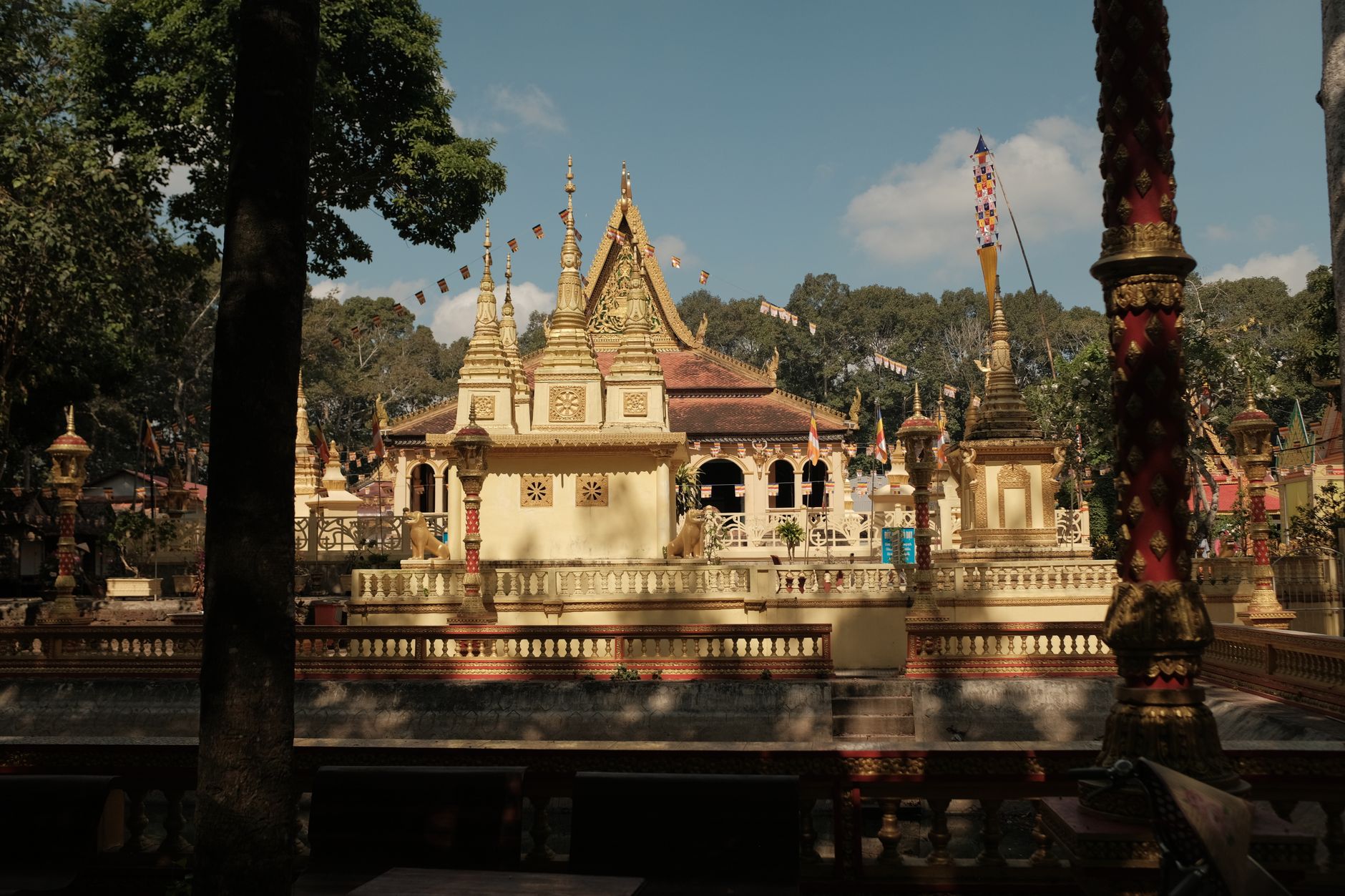
Photo by Nguyen Truong Khang on Pexels
Administrative Structure (Before 2025)
Before its merger, Tra Vinh was divided into seven districts: Cang Long, Cau Ke, Cau Ngang, Chau Thanh, Duyen Hai, Tieu Can, and Tra Cu. The district-level town Duyen Hai and the provincial capital Tra Vinh City completed the administrative picture. Below that were 11 commune-level towns, 85 communes, and nine wards. This structure managed local governance and services across the province.
Why It Matters for Travelers
Tra Vinh is not on the standard Mekong Delta tourist loop (that's usually Can Tho, Chau Doc, My Tho). But that's precisely why it's worth a detour. The Khmer Buddhist culture is genuine and visible—not packaged for backpackers. Prices are lower. The pace is slower. If you're interested in the real Mekong Delta, not the tour-boat version, spend a night or two in Tra Vinh City or one of the quieter towns. Eat local food. Visit a pagoda. Take a ferry. You'll see Vietnam that most tourists miss.
Going to Vietnam? Eat and travel smarter.
Monthly: new dishes, off-the-beaten-path destinations, and itineraries — straight to your inbox. No spam. Unsubscribe anytime.
Join 0 expats. (We just launched.)
More from tra-vinh
Other articles covering this city.

Best Chao Ca Loc in Can Tho: Where Locals Send You
Chao ca loc—rice porridge with snakehead fish—is a Can Tho breakfast ritual. Here's where locals actually eat it, what it costs, and why this city does it better than anywhere else.

Where to Stay in Can Tho: Ninh Kieu, Cai Rang, or Orchards
Can Tho's three main neighborhoods offer different angles on Mekong Delta life. Here's how to pick based on your priorities and budget.

Where to Stay in the Mekong Delta: Can Tho vs Ben Tre vs Chau Doc
Can Tho offers the most amenities, Ben Tre delivers homestay immersion on coconut farms, and Chau Doc gives you the border-town edge. Here's how to pick based on budget and vibe.
More from Southern Vietnam
Other articles covering the same region.

Landmark 81 Saigon: Observation Deck, Ice Rink, and Getting There from District 1
Landmark 81 is Vietnam's tallest building and Saigon's most visible skyline anchor. Here's what's actually inside and whether it's worth the trip.

Bitexco Financial Tower: Skydeck, Helipad Bar, and Whether the Ticket Is Worth It
Saigon's most recognizable skyscraper charges 250,000 VND to ride up to the 49th floor — here's what you actually see, and whether you should bother.

Notre Dame Cathedral Saigon: French Colonial Centerpiece in the Heart of HCMC
Saigon's Notre Dame Cathedral has been wrapped in scaffolding for years, but the square in front of it remains one of the best starting points for a colonial-era walking tour of District 1.
More in Destinations
More articles from the same category.

Paradise Cave, Quang Binh: The 31km Marble Cave That Beats Phong Nha for Photographers
Paradise Cave runs 31km through Quang Binh's karst and delivers the kind of cathedral-scale formations that Phong Nha's boat tour simply can't match. Here's how to see it properly.

Son Doong Cave: What the $3,000 Oxalis Expedition Actually Includes
Son Doong is the world's largest cave and only one operator is legally allowed to take you inside. Here is what the permit-only expedition covers and whether it is worth it.

Phong Nha Cave: Wet Cave, Dry Cave, and How to Choose
Phong Nha has two main caves worth your time — one you reach by river boat, one on foot. Here's how to pick, what each costs, and when to go.

Hoi An Lantern Festival: Full Moon Nights and How to Plan Around Them
Once a month, Hoi An cuts the electricity and lights the Ancient Town with silk lanterns. Here's what actually happens and how to not spend the evening stuck in a crowd.

Japanese Bridge Hoi An: 400 Years of History, a Restoration Row, and How to See It Right
Hoi An's Japanese Bridge has anchored the Ancient Town for four centuries. Here's what to know about its origins, the restoration that divided locals, and when to visit.

Hoi An Old Town Walking Guide: Yellow Walls, Lantern Alleys, and the Japanese Bridge
A street-level route through Hoi An's UNESCO core — old merchant houses, assembly halls, the famous Japanese Bridge, and when to walk each stretch for the best light.
Comments
Loading…