Ca Mau Province: Vietnam's Southernmost Tip and Mangrove Gateway
At Vietnam's southernmost point, Ca Mau province offers a landscape unlike anywhere else in the country: vast mangrove forests, interconnected waterways, and the rare geography of Ca Mau Cape. Discover why this remote Mekong Delta region matters to both ecology and travelers seeking quiet adventure.

Why Ca Mau Matters
Ca Mau is Vietnam's southernmost province, located in the Mekong Delta (메콩 델타 / 湄公河三角洲 / メコンデルタ) roughly 370 km south of Ho Chi Minh City. The name derives from Khmer, meaning "dark water"—a reference to the region's distinctive waterways that define daily life here. What makes Ca Mau geographically singular: Ca Mau Cape is the only place on Vietnam's mainland where you can watch the sunrise over the South China Sea and the sunset over the Gulf of Thailand on the same day.
The province occupies a peninsula bordered by sea on three sides, with an average elevation of just 0.5 to 1.5 meters above sea level. Most of the land is young, formed by centuries of sedimentation from the Mekong River system—fertile but flood-prone, especially in the south.
Landscape: Rivers, Forests, and Tides
Ca Mau is defined by water. The province contains approximately 14,000 kilometers of rivers and canals—often described as resembling a spiderweb—that facilitate inland transport and fishing. Key waterways include the Tam Giang, Ganh Hao, Song Doc, and Ca Tau rivers, along with countless smaller channels.
Ecologically, Ca Mau punches well above its weight. The province is home to 77% of the Mekong Delta's mangrove forests—roughly 35,000 hectares of inland forest and 310 kilometers of coastline. These mangroves are critical nurseries for fish and shrimp, supporting the province's aquaculture industry and providing habitat for migratory birds. The soil varies widely: acid sulfate, peat, alluvial, saline, and canal soil create a mosaic of microclimates.
Tidal range here is dramatic. Along the East Sea coast, spring tides can swing 300–350 cm, while neap tides range 180–220 cm. This rhythm shapes fishing schedules, transportation, and settlement patterns.
Climate and When to Visit
Ca Mau has a near-equatorial tropical monsoon climate. Annual rainfall averages 2,360 mm across roughly 165 rainy days per year, with humidity hovering around 85.6%. Average annual temperature is 26.5°C, with April the warmest month (around 27.6°C) and January the coolest (around 25°C)—a narrow 2.7°C range year-round.
For visitors: the dry season (November–April) offers the most stable weather for exploring by boat. Monsoon months (May–October) bring heavy rain and higher water levels—scenic, but logistically challenging.
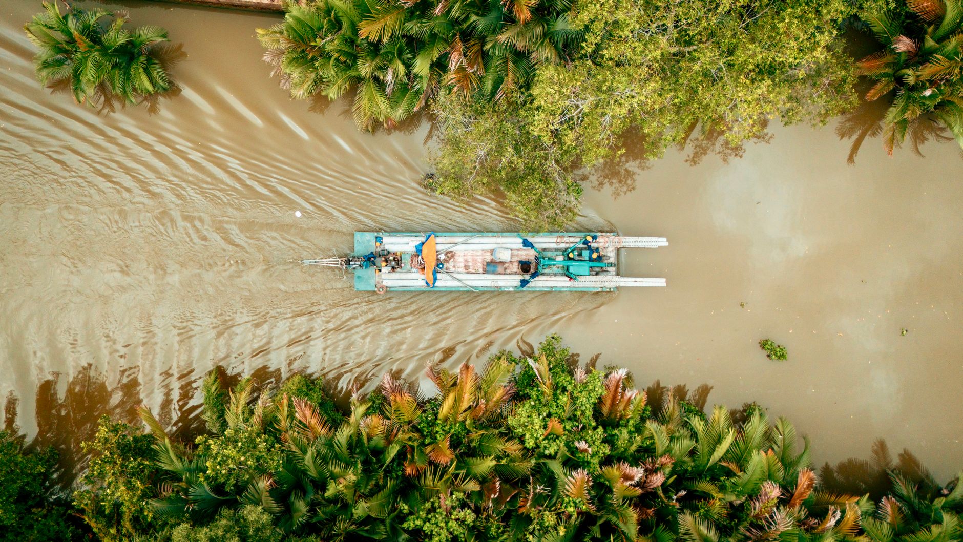
Photo by maxed. RAW on Pexels
Who Lives Here
Ca Mau has a population of approximately 2.6 million, making it the 20th most populous province in Vietnam (베트남 / 越南 / ベトナム). The vast majority are Kinh (94.5%), with significant Khmer (115,180 people) and Hoa (Chinese, 24,625 people) minorities. About 29% of residents follow an organized religion, with Buddhists accounting for roughly 22% of the provincial population—the dominant faith.
What to Do
Ca Mau offers quieter, less-touristed exploration than Hanoi or Ho Chi Minh City (호치민시 / 胡志明市 / ホーチミン市). Highlights include:
- Ca Mau Cape: The provincial "must-see" landmark—watch the tidal convergence at sunrise or sunset.
- Mangrove boat tours: Hire a guide and boat to navigate the canals and observe birds, fish traps, and traditional fishing methods.
- Aquaculture observation: Visit shrimp and fish farms to understand the province's primary industry.
- U Minh forest: One of the largest remaining wetland forests in the delta; hire local boatmen to explore.
- Local markets: Quang Long and Ca Mau City markets reflect daily life and regional seafood and agricultural trade.
Transport here is water-based. Roads exist but are rough; most locals and visitors move by boat or motorcycle. Tour operators in Can Tho or Ho Chi Minh (호치민 / 胡志明 / ホーチミン) City can arrange multi-day Mekong Delta trips that include Ca Mau.

Photo by maxed. RAW on Pexels
Getting There
Ca Mau City (the provincial capital) is roughly 350 km south of Ho Chi Minh City by road—a 6–8 hour drive. Direct flights are limited; most visitors fly into Ho Chi Minh City or Can Tho (껀터 / 芹苴 / カントー), then travel overland. Buses run daily from Ho Chi Minh City to Ca Mau City (roughly 10 hours). Once in Ca Mau, hire a boat and driver—the primary way to see the province.
A Note on Access
Ca Mau is one of Vietnam's least-visited provinces by foreign tourists, partly due to remote location and limited English-language tourism infrastructure. This is not a drawback—it means fewer crowds, more authentic interaction, and genuine quiet. Come prepared for basic accommodations, bring cash (ATMs are sparse), and consider hiring a guide who speaks English and knows the canals well.
Going to Vietnam? Eat and travel smarter.
Monthly: new dishes, off-the-beaten-path destinations, and itineraries — straight to your inbox. No spam. Unsubscribe anytime.
Join 0 expats. (We just launched.)
More from Southern Vietnam
Other articles covering the same region.

Landmark 81 Saigon: Observation Deck, Ice Rink, and Getting There from District 1
Landmark 81 is Vietnam's tallest building and Saigon's most visible skyline anchor. Here's what's actually inside and whether it's worth the trip.

Bitexco Financial Tower: Skydeck, Helipad Bar, and Whether the Ticket Is Worth It
Saigon's most recognizable skyscraper charges 250,000 VND to ride up to the 49th floor — here's what you actually see, and whether you should bother.

Notre Dame Cathedral Saigon: French Colonial Centerpiece in the Heart of HCMC
Saigon's Notre Dame Cathedral has been wrapped in scaffolding for years, but the square in front of it remains one of the best starting points for a colonial-era walking tour of District 1.
More in Destinations
More articles from the same category.

Paradise Cave, Quang Binh: The 31km Marble Cave That Beats Phong Nha for Photographers
Paradise Cave runs 31km through Quang Binh's karst and delivers the kind of cathedral-scale formations that Phong Nha's boat tour simply can't match. Here's how to see it properly.

Son Doong Cave: What the $3,000 Oxalis Expedition Actually Includes
Son Doong is the world's largest cave and only one operator is legally allowed to take you inside. Here is what the permit-only expedition covers and whether it is worth it.

Phong Nha Cave: Wet Cave, Dry Cave, and How to Choose
Phong Nha has two main caves worth your time — one you reach by river boat, one on foot. Here's how to pick, what each costs, and when to go.

Hoi An Lantern Festival: Full Moon Nights and How to Plan Around Them
Once a month, Hoi An cuts the electricity and lights the Ancient Town with silk lanterns. Here's what actually happens and how to not spend the evening stuck in a crowd.

Japanese Bridge Hoi An: 400 Years of History, a Restoration Row, and How to See It Right
Hoi An's Japanese Bridge has anchored the Ancient Town for four centuries. Here's what to know about its origins, the restoration that divided locals, and when to visit.

Hoi An Old Town Walking Guide: Yellow Walls, Lantern Alleys, and the Japanese Bridge
A street-level route through Hoi An's UNESCO core — old merchant houses, assembly halls, the famous Japanese Bridge, and when to walk each stretch for the best light.
Comments
Loading…