Quang Binh Province: Karst Mountains and Caves in Central Vietnam
Quang Binh, on Vietnam's North Central Coast, is known for limestone karst peaks, river deltas, and the UNESCO-listed Phong Nha-Ke Bang National Park. The province merged with Quang Tri in 2025, but remains a destination for cave exploration and coastal travel.

A Narrow Coastal Province
Quang Binh sits on Vietnam (베트남 / 越南 / ベトナム)'s North Central Coast, bordered by Ha Tinh to the north, Quang Tri to the south, Laos to the west, and the Dong Sea to the east. The province is notably narrow—just 40 kilometers from coast to border at its tightest—and as of June 2025, it was administratively merged with Quang Tri province. But travelers still identify Quang Binh by its name, and the region retains its distinct character: mountains and forest cover about 85% of the land.
Historically, Quang Binh shifted between Champa and Vietnamese rule before being absorbed into the Vietnamese kingdom in 1069. During the Trinh-Nguyen War (centuries later), the Gianh River marked the dividing line between north and south Vietnam. The region remained strategically important through French colonial times and beyond.
Phong Nha-Ke Bang: The Main Draw
Quang Binh's defining feature is Phong Nha-Ke Bang National Park, a UNESCO World Heritage site in the province's western mountains. The park sits along the Annamite Range, which forms the border with Laos and includes peaks between 1,000 and 1,500 meters. The highest point in the area, Phi Co Pi, reaches 2,017 meters.
Inside the park, the landscape is pure karst—limestone formations riddled with cave systems. The primary tropical forest here is home to 751 species of vascular plants, 36 of them endangered. Common trees include hopea, garcinia, and various dipterocarp species; the forest is mostly evergreen, with scattered deciduous trees that shed leaves seasonally. Seedlings grow slowly in cracks and holes where soil accumulates on the limestone, so the ecosystem recovers slowly from disturbance.
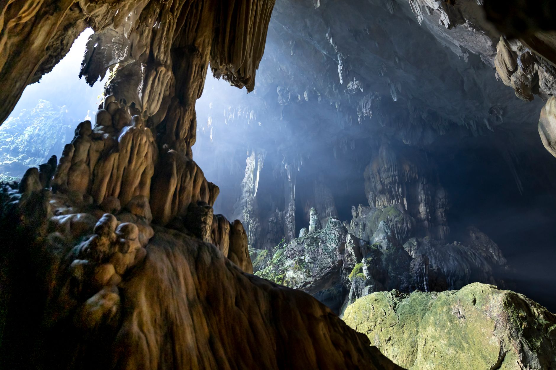
Photo by Quang Nguyen Vinh on Pexels
Five Rivers and a Long Coast
Quang Binh drains via five major rivers flowing east from the Truong Son Range to the sea: the Gianh, Ron, Nhat Le, Ly Hoa, and Dinh rivers, plus tributaries like the Son River (which passes through Phong Nha (퐁냐 / 峰牙 / フォンニャ)-Ke Bang). The province has a river density of 1.1 km per square kilometer and about 160 natural and man-made lakes holding 234 million cubic meters of fresh water.
The coastline stretches 116 kilometers and is marked by sand dunes that buffer tides. Offshore islets—Hon La, Hon Gio, Hon Nom, Hon Co, Hon Chua—are small but contribute to the province's fishery zone. Hon La bay, 4 square kilometers wide and up to 15 meters deep, has been proposed for deep-water port development.

Photo by Quang Nguyen Vinh on Pexels
Climate and Travel Timing
Quang Binh has four seasons:
- Spring (Feb–Apr): 18–25°C, warm with light rain.
- Summer (May–Jul): 35–36°C peak, hot and mostly dry with occasional storms.
- Fall (Aug–Nov): 22–28°C, rainy and cool; heaviest rains Sept–Nov.
- Winter (Dec–Jan): 12–16°C, humid with light rain.
Annual rainfall is 2,000–2,300 mm. The dry season is April to August—the best window for visiting caves and hiking.
Visiting Quang Binh Today
The main town is Dong Hoi, a modest coastal base for exploring the national park and its famous cave system (including Son Doong, one of Vietnam's largest caves). The Nhat Le River delta offers quieter riverside scenery. Most visitors come for Phong Nha-Ke Bang's trekking, caving, and wildlife—gibbons, langurs, and forest birds are common in the park.
Access: Dong Hoi airport connects to Hanoi and Ho Chi Minh City. Highway 1 runs along the coast. The merge with Quang Tri province in 2025 simplified some administrative processes, but tourism infrastructure and town names remain unchanged.
Going to Vietnam? Eat and travel smarter.
Monthly: new dishes, off-the-beaten-path destinations, and itineraries — straight to your inbox. No spam. Unsubscribe anytime.
Join 0 expats. (We just launched.)
More from Central Vietnam
Other articles covering the same region.

Paradise Cave, Quang Binh: The 31km Marble Cave That Beats Phong Nha for Photographers
Paradise Cave runs 31km through Quang Binh's karst and delivers the kind of cathedral-scale formations that Phong Nha's boat tour simply can't match. Here's how to see it properly.

Son Doong Cave: What the $3,000 Oxalis Expedition Actually Includes
Son Doong is the world's largest cave and only one operator is legally allowed to take you inside. Here is what the permit-only expedition covers and whether it is worth it.

Phong Nha Cave: Wet Cave, Dry Cave, and How to Choose
Phong Nha has two main caves worth your time — one you reach by river boat, one on foot. Here's how to pick, what each costs, and when to go.
More in Destinations
More articles from the same category.

Landmark 81 Saigon: Observation Deck, Ice Rink, and Getting There from District 1
Landmark 81 is Vietnam's tallest building and Saigon's most visible skyline anchor. Here's what's actually inside and whether it's worth the trip.

Bitexco Financial Tower: Skydeck, Helipad Bar, and Whether the Ticket Is Worth It
Saigon's most recognizable skyscraper charges 250,000 VND to ride up to the 49th floor — here's what you actually see, and whether you should bother.

Notre Dame Cathedral Saigon: French Colonial Centerpiece in the Heart of HCMC
Saigon's Notre Dame Cathedral has been wrapped in scaffolding for years, but the square in front of it remains one of the best starting points for a colonial-era walking tour of District 1.

Hoi An Lantern Festival: Full Moon Nights and How to Plan Around Them
Once a month, Hoi An cuts the electricity and lights the Ancient Town with silk lanterns. Here's what actually happens and how to not spend the evening stuck in a crowd.

Japanese Bridge Hoi An: 400 Years of History, a Restoration Row, and How to See It Right
Hoi An's Japanese Bridge has anchored the Ancient Town for four centuries. Here's what to know about its origins, the restoration that divided locals, and when to visit.

Hoi An Old Town Walking Guide: Yellow Walls, Lantern Alleys, and the Japanese Bridge
A street-level route through Hoi An's UNESCO core — old merchant houses, assembly halls, the famous Japanese Bridge, and when to walk each stretch for the best light.
Comments
Loading…