Yen Bai Province: Mountains, Lakes, and Ethnic Heritage
Yen Bai, a mountainous province in northwest Vietnam, is known for Thac Ba Lake, terraced rice fields, and its ethnic Dao communities. Once a significant historical site, it merged with Lao Cai province in 2025 but remains a compelling destination for trekkers and heritage travelers.

A Mountain Province at a Crossroads
Yen Bai province, located in Northwest Vietnam (베트남 / 越南 / ベトナム), has long been a meeting point of rivers, mountains, and cultures. Bordered by Lao Cai, Lai Chau, Son La, Phu Tho, Tuyen Quang, and Ha Giang provinces, the region covers approximately 6,900 square kilometers with a population of around 847,000 people. In June 2025, Yen Bai administratively merged with Lao Cai province, though the distinctive geography and communities that define the area remain unchanged.
Thac Ba Lake: An Unexpected Oasis
Thac Ba Lake is the province's defining natural feature—an artificial reservoir created for hydroelectric power that has become a landscape unto itself. Spanning 23,400 hectares with 1,331 islands and hills jutting from the water, the lake holds 3 to 3.9 billion cubic meters at capacity. The clear water mirrors surrounding forests, and the islands harbor several caves worth exploring: Hum, Cau Cuoi, and Bach Xa. A temple dedicated to Thac Ba stands on the lake's shore.
The lake transformed the climate of western districts, moderating what were once hot, dry zones into more temperate conditions. For visitors, it offers boat tours, island hikes, and a rare chance to see karst geology in freshwater rather than seawater context.

Photo by GIANG VU on Pexels
Terrain and Water Systems
The Red River and Chay River—both originating in Yunnan, China—shape the province's geography and settlement patterns. The Red River valley floor, particularly the Muong Lo plain, contains the best farmland and is known locally as the province's rice bowl. The terrain rises steeply from east to west and south to north, averaging about 600 meters above sea level.
Beyond the two main rivers, Yen Bai has roughly 200 smaller canals, streams, and wetlands. The Hoang Lien Son mountain range cuts through the interior. Khau Pha Pass, on National Highway 32 in Mu Cang Chai District, marks a scenic transition point between low and high terrain.
The province sits at the boundary of three main biomes: rainforest, subtropical, and temperate mountain zones, with a tropical monsoon climate. The Mu Cang Chai Species and Habitat Conservation Area (established 2004, 20,293 hectares) protects endangered species and forest habitat.
Ethnic Communities
Yen Bai is home to the Kinh majority, who have farmed the river valleys for centuries, alongside four main branches of the Dao (Yao) ethnic group:
- Dao Do (Red Yao), also called Dao Dai Ban or Dao Sung
- Dao Quan Chet (Tight-trouser Yao), also known as Dao Nga Hoang
- Dao Quan Trang (White-trouser Yao)
- Dao Lan Tuyen (Indigo Yao)
Each Dao group maintains distinct clothing, agricultural practices, and oral traditions. Villages in higher elevations often feature traditional stilt houses and markets where ethnic dress is still worn daily.
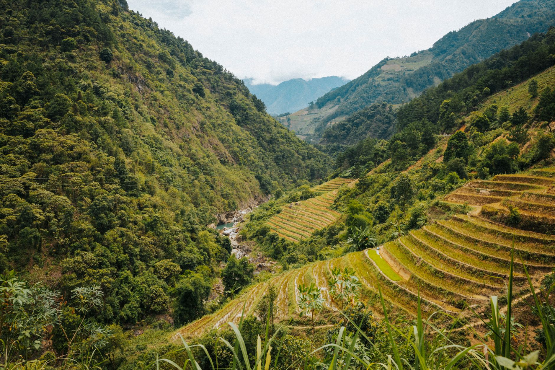
Photo by HONG SON on Pexels
Historical Context
Archaeological finds—including an 80,000-year-old skeleton from Hum Cave in Luc Yen District (1964) and bronze jars dating back 2,000 years—show human settlement stretching into deep prehistory. Stone tools uncovered in Mu Cang Chai District confirm early occupation.
The Yen Bai region became a military and administrative center during the French colonial period (1859–1954). The Yen Bai mutiny of 1930 remains a noted event in Vietnamese history. Following World War II and the Japanese occupation (1941–1945), the region was contested between French and Vietnamese forces before independence in 1954.
The Dong Cuong Festival continues as an important annual cultural gathering in the province.
Why Visit Now
Yen Bai appeals to travelers interested in mountain trekking, ethnic minority culture, and reservoir exploration. Mu Cang Chai's terraced rice fields are particularly striking in autumn and early winter. Thac Ba Lake offers a quieter alternative to the crowded limestone karst of Ha Long Bay. The region's ethnic communities remain accessible and largely off the main tourist circuit, making it suitable for visitors seeking deeper cultural immersion over standard itinerary stops.
Reach Yen Bai from Hanoi (approximately 140 km northwest) by road, or combine it with nearby Lao Cai, Lai Chau, or Son La in a multi-day mountain loop.
Going to Vietnam? Eat and travel smarter.
Monthly: new dishes, off-the-beaten-path destinations, and itineraries — straight to your inbox. No spam. Unsubscribe anytime.
Join 0 expats. (We just launched.)
More from Northern Vietnam
Other articles covering the same region.

Hoa Lu Ancient Capital: Vietnam's First Kingdom and How to Visit from Ninh Binh
Hoa Lu was Vietnam's first royal capital, and the two temple complexes that survive are among the most atmospheric historical sites in the north.

Hoan Kiem Lake: The Sword Legend, Ngoc Son Temple, and When to Visit
Hoan Kiem Lake sits at the center of Hanoi's Old Quarter — here's the legend behind it, how to walk it properly, and when the streets actually belong to you.

Lung Cu Flag Tower: Vietnam's Northernmost Point
The drive to Lung Cu Flag Tower takes you to Vietnam's northernmost point at 1,500 metres. It's a half-day trip from Dong Van with a steep climb, mountain views, and nearby Hmong villages.
More in Destinations
More articles from the same category.

Landmark 81 Saigon: Observation Deck, Ice Rink, and Getting There from District 1
Landmark 81 is Vietnam's tallest building and Saigon's most visible skyline anchor. Here's what's actually inside and whether it's worth the trip.

Bitexco Financial Tower: Skydeck, Helipad Bar, and Whether the Ticket Is Worth It
Saigon's most recognizable skyscraper charges 250,000 VND to ride up to the 49th floor — here's what you actually see, and whether you should bother.

Notre Dame Cathedral Saigon: French Colonial Centerpiece in the Heart of HCMC
Saigon's Notre Dame Cathedral has been wrapped in scaffolding for years, but the square in front of it remains one of the best starting points for a colonial-era walking tour of District 1.

Paradise Cave, Quang Binh: The 31km Marble Cave That Beats Phong Nha for Photographers
Paradise Cave runs 31km through Quang Binh's karst and delivers the kind of cathedral-scale formations that Phong Nha's boat tour simply can't match. Here's how to see it properly.

Son Doong Cave: What the $3,000 Oxalis Expedition Actually Includes
Son Doong is the world's largest cave and only one operator is legally allowed to take you inside. Here is what the permit-only expedition covers and whether it is worth it.

Phong Nha Cave: Wet Cave, Dry Cave, and How to Choose
Phong Nha has two main caves worth your time — one you reach by river boat, one on foot. Here's how to pick, what each costs, and when to go.
Comments
Loading…