Lung Cu Flag Tower: Vietnam's Northernmost Point
The drive to Lung Cu Flag Tower takes you to Vietnam's northernmost point at 1,500 metres. It's a half-day trip from Dong Van with a steep climb, mountain views, and nearby Hmong villages.

Lung Cu Flag Tower sits at 1,500 metres above sea level, marking Vietnam (베트남 / 越南 / ベトナム)'s northernmost geographic point. The site is in Ha Giang province, in the far north of the Tay Nguyen Plateau. Most visitors come as a side trip from Dong Van, 20 km to the south, or slot it into the wider Ma Pi Leng loop.
The drive from Dong Van
From Dong Van town, take the road north towards Meo Vac. After about 15 km, you'll see a signed turnoff to the right (east) towards Lung Cu. The final 5 km climbs steeply through pine forest and past scattered Hmong farmhouses. The road is paved but narrow; in wet season (May–October), landslide warnings appear. Most tourists hire a motorbike driver in Dong Van (around 300,000–400,000 VND for a round trip with waiting time) or rent their own (200,000 VND per day for a manual bike). If you're self-driving a car, confirm road conditions at your Dong Van hotel first—not all roads are passable year-round.
The flag tower and the climb
You'll arrive at a small parking area and souvenir stalls. The actual tower is another 500 metres uphill on foot. The path is steep, concrete-stepped in places, and can be slippery in rain. Most people take 15–20 minutes to reach it. The tower itself is a white concrete structure, about 15 metres tall, with a Vietnamese flag flying from the top. It's modest, not dramatic—but the altitude and the fact that you're standing at Vietnam's northernmost extremity give it weight.
From the tower, you can see into Yunnan province across the border. The landscape rolls away in green ridges and valleys. On clear days (most common October–April), the view stretches 20–30 km. The Chinese side looks very similar: limestone karst, small villages, forested slopes. There's a border checkpoint below the tower, but tourists don't cross.
Hmong settlements nearby
The villages around Lung Cu are predominantly "Hmong Trang" (white Hmong), identifiable by the women's white headscarves and embroidered hemp jackets. Several hamlets lie within walking distance—Khau Vai and Khau Phong are the most visited. You can hire a guide in Dong Van or organize a homestay night for 200,000–300,000 VND (usually includes dinner, breakfast, and a family tour). The houses are timber-frame, thatched or corrugated-iron roofed, built on stilts. Women still weave and embroider by hand. There's no tourism infrastructure here—no restaurants, no shops—so bring cash and manage expectations. You're not visiting a cultural show; you're passing through a working agricultural community.

Photo by Vietnam Hidden Light on Pexels
Best season
October to November is ideal: cool, dry, and clear skies. December to February is also good but can be foggy. March and April are warm and clear. May to September brings daily rain, mist, and poor visibility; the road becomes treacherous. Winter (January–February) can see light snow at the summit, but this is rare. Avoid the Tet holiday (late January/early February), when every road in Ha Giang (하장 / 河江 / ハーザン) clogs with domestic visitors.
Combining with the Ma Pi Leng loop
Most visitors don't drive to Lung Cu in isolation. The town sits on the western edge of the broader Ha Giang loop, a 350 km motorcycle circuit that includes Meo Vac, Yen Minh, and the dramatic Ma Pi Leng Pass. If you're already in Dong Van (usually the base for the loop), you can add Lung Cu as a half-day detour. A full loop takes 2–4 days depending on stops and pace. Stay overnight in Dong Van, do Lung Cu and a Hmong village one day, then continue east towards Meo Vac and the Ma Pi Leng Pass the next.
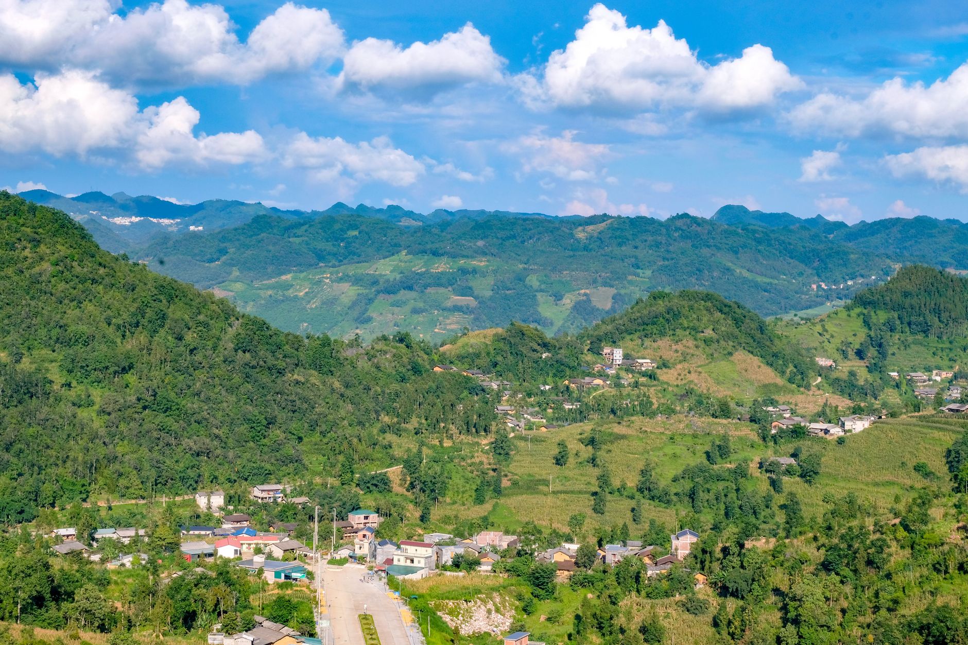
Photo by Du Tử Mộng on Pexels
What it means to Vietnamese
The tower is more than a viewpoint. It's a symbol of national identity and sovereignty—a flagpole at the edge of the map. For many Vietnamese tourists, especially from the south, visiting Lung Cu is a patriotic pilgrimage, a way to "touch" the nation's boundary. You'll see school groups, military personnel, and families posing with the flag. The site features in school history textbooks. For Hmong locals, it's a landmark and a source of seasonal work (guides, homestay income, souvenir sales), though the economic benefit remains modest.
Practical notes
Bring water and snacks; there are no facilities at the tower itself. Temperatures drop sharply at altitude—bring a fleece even in warm season. Guides are helpful if you want to visit Hmong villages, but not essential for the flag tower itself. Most people spend 2–3 hours at the site (drive, walk, views, return). If you're arriving from Hanoi, expect 8–10 hours of travel to reach Dong Van; fly to Hanoi first, then take a bus or rent a driver for the journey north.
Going to Vietnam? Eat and travel smarter.
Monthly: new dishes, off-the-beaten-path destinations, and itineraries — straight to your inbox. No spam. Unsubscribe anytime.
Join 0 expats. (We just launched.)
More from Ha Giang
Other articles covering this city.

7 Days in Vietnam's Ethnic Minority Villages: A Northern Loop
A tested itinerary through Ha Giang, Sapa, and Mai Chau targeting Hmong, Dao, and Thai villages. Routes, homestays, transport, food stops, and real costs in VND.

Best Cha Man in Ha Giang: Where Locals Eat
Ha Giang's version of cha man is leaner, more herb-forward, and almost always served at dawn. Here's where locals line up and what makes it worth the trip.

7 Days Vietnam Adventure: Caving, Motorbike & Jungle
Combine world-class cave exploration in Phong Nha with a challenging motorbike loop through Ha Giang's limestone karst. Three days underground, three days on two wheels.
More from Northern Vietnam
Other articles covering the same region.

Hoa Lu Ancient Capital: Vietnam's First Kingdom and How to Visit from Ninh Binh
Hoa Lu was the seat of Vietnam's first independent dynasties in the 10th century. Two surviving temples anchor a quiet bike ride through rice fields just outside Ninh Binh.

Perfume Pagoda Day Trip from Hanoi: Boat, Hike, and Festival Season
A half or full-day pilgrimage from Hanoi to the Perfume Pagoda involves a scenic boat ride through limestone karst, a trek or cable car ascent, and crowds during Tet season. Here's what to expect and how to plan.

Hanoi Old Quarter Walking Guide: 36 Streets, Street Food & Craft Alleys
The 36 streets of Hanoi's Old Quarter were named after the guilds that dominated them—silk, silver, tin, paper. Here's how to walk them, eat on them, and see which craft trades still survive.
More in Destinations
More articles from the same category.

Son Doong Cave: Inside the $3,000 Oxalis Expedition
Son Doong is the world's largest cave by volume—and the only way in is a 4-day permit-exclusive tour with Oxalis. Here's what you actually get, who should go, and what cheaper caves offer instead.

Phong Nha Cave: Boat Tours, Dry Caves, and How to Choose
Phong Nha-Ke Bang has two main cave experiences: the iconic river boat through Phong Nha Cave itself, and the dry trek into Tien Son. Here's how to pick, what to expect, and when to go.

Hoi An Lantern Festival: Full Moon Nights and How to Plan Around Them
The Hoi An Lantern Festival happens on the 14th lunar day each month. Electricity shuts off, lanterns float on the Thu Bon River, and crowds triple. Here's how to time your visit and actually enjoy it.

Japanese Bridge in Hoi An: What to Know Before You Visit
The 400-year-old Japanese Bridge is Hoi An's most iconic landmark. Here's how to see it properly—and avoid the crowds.

Thien Mu Pagoda in Hue: Seven Stories Above the Perfume River
Hue's most recognizable landmark rises 21 metres above the Perfume River. This is the story behind the tower, how to get there, and when to visit without the tour groups.

Hoan Kiem Lake: History, Temples, and the Best Time to Walk
The turtle legend, Ngoc Son Temple, and a 2-km loop around Hanoi's most visited lake. Best visited early morning or when Old Quarter streets close to cars.
Comments
Loading…