Quy Nhon and Binh Dinh: Coastal History, Cham Ruins, and Rice Delta
Binh Dinh province spans Vietnam's south-central coast with a mix of mountains, beaches, and a fertile river delta. The provincial capital Quy Nhon was once the seat of the Tay Son dynasty and sits near the ruins of Vijaya, an ancient Champa city-state.

A Coastal Province With Layers of History
Binh Dinh sits on Vietnam (베트남 / 越南 / ベトナム)'s south-central coast, sandwiched between Quang Ngai to the north and Phu Yen to the south, with Gia Lai's mountains rising inland. The 6,066 km² province is home to over 1.5 million people, most living in the fertile lowlands around Quy Nhon and the delta of the Con River.
What makes Binh Dinh worth a detour: it's less touristed than nearby Da Nang or Nha Trang (냐짱 / 芽庄 / ニャチャン), but carries real historical weight. You'll find Champa ruins, a dynasty capital, and a working agricultural landscape that still feels lived-in rather than packaged.
The Champa Kingdom and Vijaya
Binh Dinh is believed to be one of the earliest Cham settlements in what is now Vietnam. By the 11th and 12th centuries, the Champa city-state of Vijaya had become a major power, centered on what is now Quy Nhon and the lower Con River valley.
Vijaya's architecture stood apart from other Champa centers. Most Cham structures used brick, but Vijaya blended stone and brick—a labor-intensive approach that suggests either influence from the Khmer empire (Angkor) or access to a large workforce. The city thrived as a port and trade hub until war with Vietnamese forces in the 15th century, and Vijaya was defeated in 1471, marking the decline of Champa as a regional power.
Today, scattered Cham towers and ruins dot the province, though many are overgrown or fragmentary. Quy Nhon itself has a small Cham Museum if you want context before exploring.
Quy Nhon: Former Tay Son Capital
Quy Nhon, the provincial capital, served as the seat of the "Tay Son" dynasty—named after the Tay Son district where the family originated. From here, the Tay Sons ruled briefly before internal conflict and war consumed them in 1802.
Today Quy Nhon is a working port city with a long, underdeveloped beach, seafood restaurants along the waterfront, and enough guesthouses to overnight comfortably. It's not packaged for tourists, which is part of its appeal. You can eat fresh crab at the harbor, walk the colonial-era streets inland, and see a functioning Vietnamese city without the crowds of Hanoi or Ho Chi Minh City.
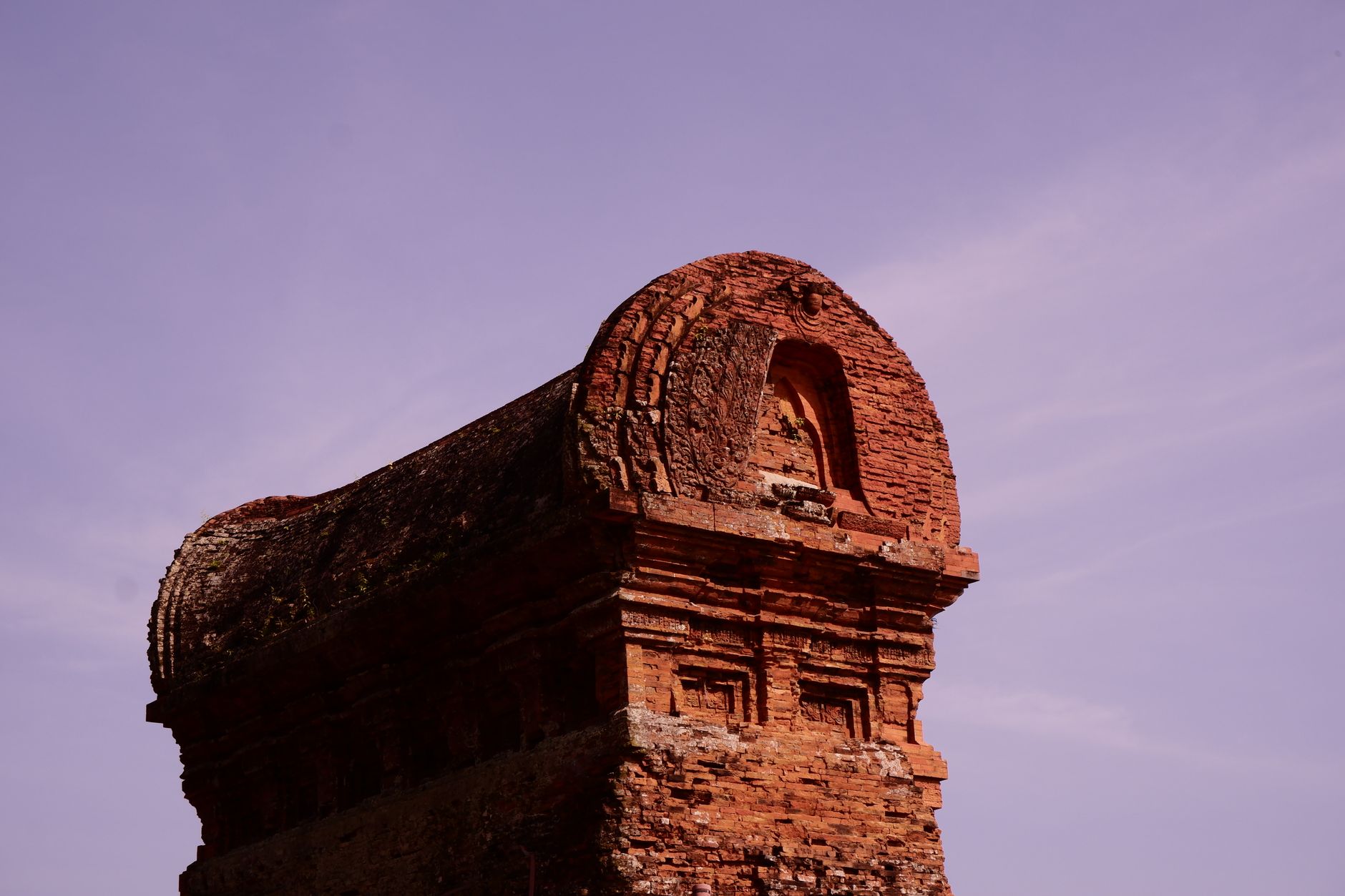
Photo by Thái Nguyễn on Pexels
Geography: Mountains, Rivers, and Coastal Lowlands
Binh Dinh's landscape is split. The west is mountainous—peaks reach 1200 meters in An Lao district in the northwest—and forms a natural border with Gia Lai. The coast and central lowlands are gentler, dominated by the Con River delta. This delta has historically been the population and economic hub, fertile enough to support rice cultivation and fishing.
The major passes—An Khe to Gia Lai, Cu Mong to Phu Yen, Binh De toward Quang Ngai—are mountainous and scenic drives if you're traveling between provinces on National Route 1. The coast itself is rocky and moderate; beaches exist but aren't as famous as those in Nha Trang or Da Nang (다낭 / 岘港 / ダナン).
Several rivers drain the province. The Con is largest and most navigable, historically crucial for trade. Others include the Lai Giang, My Cat, and Ha Thanh rivers, each supporting smaller agricultural communities.
What to Do: A Short Itinerary
In Quy Nhon:
- Walk the harbor at dawn; breakfast on "[com tam](/posts/com-tam-saigon (사이공 / 西贡 / サイゴン)-broken-rice)" (broken rice) or pho at a street stall.
- Visit Cham Museum for context on local history.
- Eat fresh seafood at waterfront restaurants in the evening.
- Stay 1–2 nights; the city is small but unhurried.
Outside the city:
- Day trip to nearby Cham tower ruins (ask your guesthouse for directions; many are on motorbike-accessible dirt roads).
- Visit the Con River delta if you're interested in agricultural tourism—rice fields, coconut plantations, and small fishing villages.
- Hike or motorbike through the western mountainous districts (An Lao, Vinh Thanh) if you have time and an adventurous spirit; these areas see few foreign visitors.
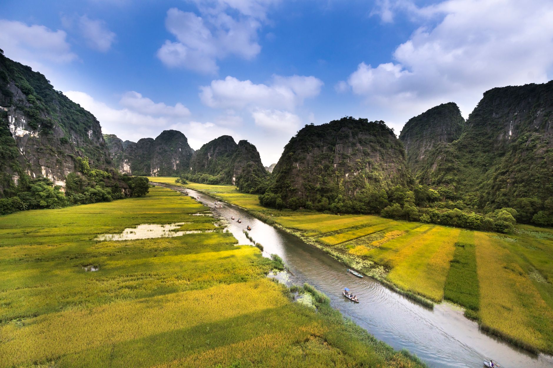
Photo by Quang Nguyen Vinh on Pexels
When to Visit
Binh Dinh is tropical and monsoon-influenced. The dry season (October to April) is most comfortable for travel. May to September brings heat and occasional typhoons. Typhoon season can be intense; check forecasts before a coastal visit.
Getting There
Quy Nhon has a small airport with flights from Hanoi and Ho Chi Minh City (호치민시 / 胡志明市 / ホーチミン市). Overnight buses from both cities also serve the province. National Route 1 connects Quy Nhon to Da Nang (north) and Nha Trang (south)—both 4–5 hours by bus.
Local transport within Binh Dinh is by motorbike taxi, rental motorbike, or minibus. Organized tour operators based in Quy Nhon can arrange day trips to ruins and rural areas if you don't want to navigate independently.
Going to Vietnam? Eat and travel smarter.
Monthly: new dishes, off-the-beaten-path destinations, and itineraries — straight to your inbox. No spam. Unsubscribe anytime.
Join 0 expats. (We just launched.)
More from Central Vietnam
Other articles covering the same region.

Paradise Cave, Quang Binh: The 31km Marble Cave That Beats Phong Nha for Photographers
Paradise Cave runs 31km through Quang Binh's karst and delivers the kind of cathedral-scale formations that Phong Nha's boat tour simply can't match. Here's how to see it properly.

Son Doong Cave: What the $3,000 Oxalis Expedition Actually Includes
Son Doong is the world's largest cave and only one operator is legally allowed to take you inside. Here is what the permit-only expedition covers and whether it is worth it.

Phong Nha Cave: Wet Cave, Dry Cave, and How to Choose
Phong Nha has two main caves worth your time — one you reach by river boat, one on foot. Here's how to pick, what each costs, and when to go.
More in Destinations
More articles from the same category.

Landmark 81 Saigon: Observation Deck, Ice Rink, and Getting There from District 1
Landmark 81 is Vietnam's tallest building and Saigon's most visible skyline anchor. Here's what's actually inside and whether it's worth the trip.

Bitexco Financial Tower: Skydeck, Helipad Bar, and Whether the Ticket Is Worth It
Saigon's most recognizable skyscraper charges 250,000 VND to ride up to the 49th floor — here's what you actually see, and whether you should bother.

Notre Dame Cathedral Saigon: French Colonial Centerpiece in the Heart of HCMC
Saigon's Notre Dame Cathedral has been wrapped in scaffolding for years, but the square in front of it remains one of the best starting points for a colonial-era walking tour of District 1.

Hoi An Lantern Festival: Full Moon Nights and How to Plan Around Them
Once a month, Hoi An cuts the electricity and lights the Ancient Town with silk lanterns. Here's what actually happens and how to not spend the evening stuck in a crowd.

Japanese Bridge Hoi An: 400 Years of History, a Restoration Row, and How to See It Right
Hoi An's Japanese Bridge has anchored the Ancient Town for four centuries. Here's what to know about its origins, the restoration that divided locals, and when to visit.

Hoi An Old Town Walking Guide: Yellow Walls, Lantern Alleys, and the Japanese Bridge
A street-level route through Hoi An's UNESCO core — old merchant houses, assembly halls, the famous Japanese Bridge, and when to walk each stretch for the best light.
Comments
Loading…