Lao Cai Province: Mountains, Minorities, and Fansipan
Lao Cai is Vietnam's northwesternmost province, home to Fansipan (the country's highest peak) and Sa Pa, a cool-weather hill station famous for its Hmong markets and terraced rice paddies. A destination for trekking, wildlife watching, and experiencing ethnic minority culture.

Gateway to the Northwest
Lao Cai province covers 13,257 square kilometers in northern Vietnam (베트남 / 越南 / ベトナム), anchored by two main cities: Lao Cai (a border trading town) and Sa Pa (a hill station at 1,600 meters elevation). The province is named from Lao Nhai (老街), meaning "Old Town" in Vietnamese—a reference to its role as a colonial-era market center. When French mapmakers rendered it phonetically, Vietnamese speakers read it as Lao Cai, and the spelling stuck.
The province is dominated by mountains. Fansipan, Vietnam's highest peak at 3,143 meters, sits within Hoang Lien National Park (2,466 hectares, upgraded from a nature reserve in 2006). The mountain is often snow-capped in winter and visible from Sa Pa (사파 / 沙坝 / サパ) across the Muong Hoa Valley.
Sa Pa: The Hill Station
Sa Pa is the region's tourism anchor. At 1,600 meters above sea level, the town serves as a market hub for Hmong groups—Red, Black, Green, and Flower Hmong each occupy distinct valleys and terraced farms around town. The nickname "queen of mountains" reflects both its elevation and its role as a cultural crossroads.
Temperatures in Sa Pa drop below 0°C in winter, with frequent frost and fog. Summers are cool compared to the Mekong Delta (메콩 델타 / 湄公河三角洲 / メコンデルタ). This climate supports unique agriculture: red-yellow humus soil (30% of district land) favors medicinal plants, fruit trees, and vegetables. Locals cultivate ginger and other highland crops.
Geography and Terrain
The province shares borders with Tuyen Quang, Son La, Lai Chau, and Phu Tho provinces to the south and west. Terrain is highly varied: alluvial soils along the Red River (1.47% of land), oxisol in lowland areas (40% below 900m altitude), and humus-rich mountain soil in Sa Pa district (11.42% of land). The Red River bisects the province for 130 kilometers, flowing north-south toward Hanoi. Other major waterways include the Chay and Nam Ti rivers.
Groundwater is abundant: 4,448 million cubic meters in reserves, with 30 million cubic meters potable. The province also has four identified mineral water sources—a resource for bottled water and local spas.

Photo by Quang Nguyen Vinh on Pexels
Flora and Fauna
Forests cover 2,789 square kilometers (43.87% of the province), split between natural forest and plantations. Hoang Lien National Park retains about 12 square kilometers of dense forest despite centuries of agricultural use and ginger cultivation.
Altitude creates distinct ecosystems. Below 1,500 meters, dense tropical forest dominates. Between 2,500 and 2,800 meters lies an elfin forest—a mist-shrouded zone where Tsuga yunnanensis trees stay below 8 meters, blanketed in moss. Above 2,800 meters, bamboo and rhododendron take over.
Wildlife is rich. Early scientific surveys (1929) by French biologist Delacour recorded clouded leopards, black gibbons, stump-tailed macaques, and Asiatic black bears. Sa Pa's forests today support 150 bird species, including endemic North Vietnamese species like the red-vented barbet and white-throated laughingthrush. The area is also a migratory corridor for raptors—1,884 sightings recorded in Hoang Lien.
Climate and When to Visit
Lao Cai has two seasons. October to March brings a dry, cold spell (average 23°C annually, but Sa Pa often freezes). April to September is the tropical monsoon season, wet and warm in lowlands, cool and misty in highlands. Terraced rice paddies are most photogenic July–August (lush and green) and September–October (approaching harvest).
If you want to hike Fansipan or trek in Sa Pa, May–September offers the most stable weather, though afternoon clouds are frequent. Late September and October are ideal—cool, clear mornings, dramatic afternoon fog.
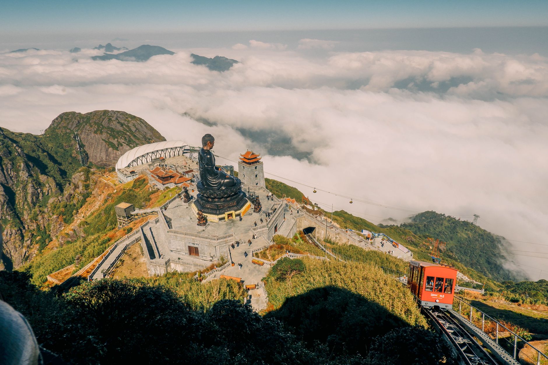
Photo by Quý Nguyễn on Pexels
Resources and Mining
Lao Cai is mineral-rich: 30 types identified, including 53 million tons of copper, 15 million tons of molybdenum, apatite, and 2.5 billion tons of iron. About 150 mines operate across the province. This resource extraction is the economic engine outside of tourism, so expect some industrial activity in lower-altitude towns.
Visiting
Most travelers base themselves in Sa Pa for 2–4 days: day hikes through rice paddies, market visits to see Hmong vendors, and either a guided trek or cable car ride to Fansipan's summit. The town has guesthouses, homestays, and restaurants catering to tourists. Lao Cai city (60 kilometers south, 1.5 hours by road) is a transit hub and border crossing for travelers heading to/from China; it lacks Sa Pa's tourism infrastructure but offers a glimpse of a working Vietnamese town.
The Red River Valley route from Hanoi (하노이 / 河内 / ハノイ) to Lao Cai is scenic, with karst limestone and agricultural villages. Allow 4–5 hours by car or minibus.
Going to Vietnam? Eat and travel smarter.
Monthly: new dishes, off-the-beaten-path destinations, and itineraries — straight to your inbox. No spam. Unsubscribe anytime.
Join 0 expats. (We just launched.)
More from lao-cai
Other articles covering this city.

3 Days in Bac Ha and Sapa: Sunday Market and Hmong Villages
Combine Bac Ha's chaotic Sunday market with Sapa's mountain villages and cool-season trekking. This route feels less touristy than Sapa alone and gives you genuine textile trading and ethnic-minority life.

Sapa: Vietnam's Alpine Town and Mountain Gateway
Sapa is a 1,600-meter highland town in northwest Vietnam where Hmong, Dao, and Tay communities have lived for centuries. Known for terraced rice fields, Fansipan mountain, and cool climate, it evolved from a French hill station into Vietnam's primary mountain trekking destination.
More from Northern Vietnam
Other articles covering the same region.

Hoa Lu Ancient Capital: Vietnam's First Kingdom and How to Visit from Ninh Binh
Hoa Lu was Vietnam's first royal capital, and the two temple complexes that survive are among the most atmospheric historical sites in the north.

Hoan Kiem Lake: The Sword Legend, Ngoc Son Temple, and When to Visit
Hoan Kiem Lake sits at the center of Hanoi's Old Quarter — here's the legend behind it, how to walk it properly, and when the streets actually belong to you.

Lung Cu Flag Tower: Vietnam's Northernmost Point
The drive to Lung Cu Flag Tower takes you to Vietnam's northernmost point at 1,500 metres. It's a half-day trip from Dong Van with a steep climb, mountain views, and nearby Hmong villages.
More in Destinations
More articles from the same category.

Landmark 81 Saigon: Observation Deck, Ice Rink, and Getting There from District 1
Landmark 81 is Vietnam's tallest building and Saigon's most visible skyline anchor. Here's what's actually inside and whether it's worth the trip.

Bitexco Financial Tower: Skydeck, Helipad Bar, and Whether the Ticket Is Worth It
Saigon's most recognizable skyscraper charges 250,000 VND to ride up to the 49th floor — here's what you actually see, and whether you should bother.

Notre Dame Cathedral Saigon: French Colonial Centerpiece in the Heart of HCMC
Saigon's Notre Dame Cathedral has been wrapped in scaffolding for years, but the square in front of it remains one of the best starting points for a colonial-era walking tour of District 1.

Paradise Cave, Quang Binh: The 31km Marble Cave That Beats Phong Nha for Photographers
Paradise Cave runs 31km through Quang Binh's karst and delivers the kind of cathedral-scale formations that Phong Nha's boat tour simply can't match. Here's how to see it properly.

Son Doong Cave: What the $3,000 Oxalis Expedition Actually Includes
Son Doong is the world's largest cave and only one operator is legally allowed to take you inside. Here is what the permit-only expedition covers and whether it is worth it.

Phong Nha Cave: Wet Cave, Dry Cave, and How to Choose
Phong Nha has two main caves worth your time — one you reach by river boat, one on foot. Here's how to pick, what each costs, and when to go.
Comments
Loading…