Quang Nam Province: Central Vietnam's Coast and History
Quang Nam sits at the heart of Central Vietnam's coast, home to the UNESCO-listed ancient town of Hoi An and the Champa ruins of My Son. Bordered by mountains to the west and the South China Sea to the east, it's a province where 2,200 years of trade, dynastic conflict, and cultural exchange shaped everything from the architecture to the food.

Quang Nam is a coastal province in Central Vietnam (베트남 / 越南 / ベトナム), roughly 820 kilometers south of Hanoi via National Highway 1A. It borders Hue to the north, Da Nang to the northeast, Kon Tum inland to the west, and Quang Ngai to the south. The province is split into two main cities: Tam Ky (the capital) and Hoi An, the ancient trading town that draws most visitors.
A Kingdom Within a Kingdom
For nearly a thousand years, this stretch of coast was the heart of the Champa kingdom — a maritime power that controlled the trade routes from the Central Highlands (중부 고원 / 中部高原 / 中部高原). When Vietnamese forces expanded southward in the 1400s, Champa's political center shifted further south. But Hoi An remained a crucial port, funneling high-grade silk, fabrics, pepper, porcelain, and elephant tusks through its harbor to Chinese and Japanese merchants.
The Dutch came next, followed by the French. Alexandre de Rhodes, who romanized Vietnamese script in the 1600s, worked in this region. A military alliance between French and Vietnamese royalty was signed here during the Tay Son period, marking the beginning of what would become colonial French Indochina.
Geography and Landscape
Quang Nam covers 10,574 square kilometers and rises in tiers from the coast inland. The eastern plain hugs the South China Sea; the central midlands sit between; the western mountains account for 72 percent of the province and include Ngoc Linh, the highest peak in the Truong Son range at 2,598 meters.
The climate is tropical monsoon. Temperatures average above 25°C year-round. Rainfall concentrates between October and December (over 70 percent of annual totals). The Vu Gia-Thu Bon river system feeds the coastal plains — the same waterways that once powered the Champa kingdom's agricultural surplus and, later, supported French colonial rice exports.

Photo by Quang Nguyen Vinh on Pexels
UNESCO and Modern Tourism
Quang Nam holds more UNESCO World Cultural Heritage designations than any other Vietnamese province: Hoi An (호이안 / 会安 / ホイアン) Ancient Town and My Son Sanctuary. Both draw serious tourism. Hoi An's narrow lanes preserve Chinese and Japanese merchant-house architecture from the 17th–18th centuries; My Son's brick-and-stone temples show what Champa architectural ambition looked like before warfare and weather eroded them into ruins.
The Cham Islands, off the coast, feature a 517-meter peak and are accessible by boat from Hoi An.
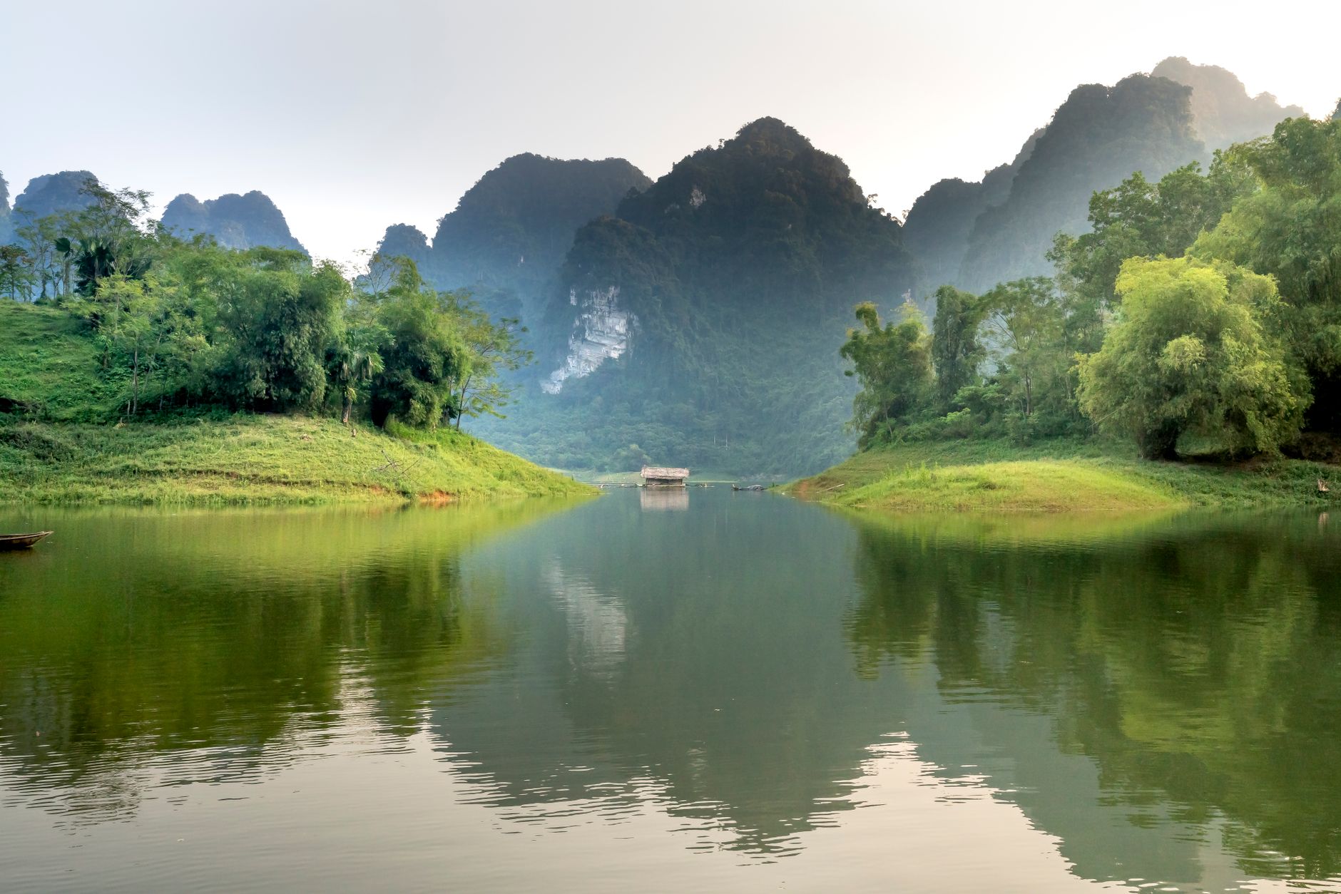
Photo by Quang Nguyen Vinh on Pexels
Administrative History
In 1997, Quang Nam was separated from the larger Quang Nam-Da Nang (다낭 / 岘港 / ダナン) administrative unit when Da Nang became its own city. Before that, the province had been divided in 1962 (with the southern half becoming Quang Tinh province) and reunited in 1976 after national unification. The name "Quang Nam" itself — "quang" meaning to expand, "nam" meaning south — was established by King Le Thanh Tong in 1471 as a declaration of Vietnamese expansion into Champa territory.
Why It Matters for Visitors
Quang Nam is the geographic and historical bridge between Hanoi (하노이 / 河内 / ハノイ) and Ho Chi Minh City. It's where the trade networks of Asia once converged, where empires collided, and where two UNESCO sites sit within striking distance of each other. The terrain — flat coast giving way to serious mountains — makes it a natural base for mixing beach time, ancient-town exploration, and highland trekking. The provincial capital, Tam Ky, rarely appears in guidebooks; Hoi An steals all the attention. But the province's 2,200-year arc from Sa Huynh culture to Champa kingdom to French colonial outpost to modern beach destination is Vietnam's broader story compressed into one stretch of coast.
Going to Vietnam? Eat and travel smarter.
Monthly: new dishes, off-the-beaten-path destinations, and itineraries — straight to your inbox. No spam. Unsubscribe anytime.
Join 0 expats. (We just launched.)
More from Hoi An
Other articles covering this city.

Hoi An Old Town Walking Guide: Yellow Walls, Lantern Alleys, and the Japanese Bridge
A street-level route through Hoi An's UNESCO core — old merchant houses, assembly halls, the famous Japanese Bridge, and when to walk each stretch for the best light.
Best Tau Hu in Hoi An: Where Locals Send You
Tau hu—silky tofu soup—tastes different in Hoi An. Here's where locals actually eat it, and why.

5 Days in Vietnam During Monsoon Season: What Actually Works
A tested itinerary for traveling Vietnam in the wet season. Choose destinations that stay dry, time activities around rain patterns, and eat your way through slack-season food.
More from Central Vietnam
Other articles covering the same region.

Paradise Cave, Quang Binh: The 31km Marble Cave That Beats Phong Nha for Photographers
Paradise Cave runs 31km through Quang Binh's karst and delivers the kind of cathedral-scale formations that Phong Nha's boat tour simply can't match. Here's how to see it properly.

Son Doong Cave: What the $3,000 Oxalis Expedition Actually Includes
Son Doong is the world's largest cave and only one operator is legally allowed to take you inside. Here is what the permit-only expedition covers and whether it is worth it.

Phong Nha Cave: Wet Cave, Dry Cave, and How to Choose
Phong Nha has two main caves worth your time — one you reach by river boat, one on foot. Here's how to pick, what each costs, and when to go.
More in Destinations
More articles from the same category.

Landmark 81 Saigon: Observation Deck, Ice Rink, and Getting There from District 1
Landmark 81 is Vietnam's tallest building and Saigon's most visible skyline anchor. Here's what's actually inside and whether it's worth the trip.

Bitexco Financial Tower: Skydeck, Helipad Bar, and Whether the Ticket Is Worth It
Saigon's most recognizable skyscraper charges 250,000 VND to ride up to the 49th floor — here's what you actually see, and whether you should bother.

Notre Dame Cathedral Saigon: French Colonial Centerpiece in the Heart of HCMC
Saigon's Notre Dame Cathedral has been wrapped in scaffolding for years, but the square in front of it remains one of the best starting points for a colonial-era walking tour of District 1.

Linh Ung Pagoda Son Tra: The 67m Lady Buddha Watching Over Da Nang Bay
On the forested slopes of Son Tra peninsula, a 67-metre white Buddha figure stands visible from almost anywhere in Da Nang — and the pagoda grounds are free to enter.

Hoa Lu Ancient Capital: Vietnam's First Kingdom and How to Visit from Ninh Binh
Hoa Lu was Vietnam's first royal capital, and the two temple complexes that survive are among the most atmospheric historical sites in the north.

Hoan Kiem Lake: The Sword Legend, Ngoc Son Temple, and When to Visit
Hoan Kiem Lake sits at the center of Hanoi's Old Quarter — here's the legend behind it, how to walk it properly, and when the streets actually belong to you.
Comments
Loading…