Quang Ngai Province: Coast, Mountains, and Industrial Heritage
Quang Ngai sits 130 km south of Da Nang on Vietnam's central coast, where mountains meet a 129 km shoreline. The province spans from lowland fishing villages to highland ethnic minority communities, anchored economically by the Dung Quat refinery and a working fishing culture centered on Ly Son island.

Quang Ngai province occupies a slim wedge of Vietnam (베트남 / 越南 / ベトナム)'s South Central Coast, squeezed between the sea and the western mountains. It's less touristy than Quang Nam or Binh Dinh to the north and south, which makes it quieter—and more genuine as a glimpse of central Vietnamese life outside the postcard towns.
The province sits 130 km south of Da Nang, 820 km north of Ho Chi Minh City, and 908 km south of Hanoi, all reachable via National Route 1. The provincial capital, Quang Ngai City, is concentrated with about 40% of the province's population; the rest scatter across coastal lowlands and five sparsely peopled western districts where Hre and other highland ethnic groups live.
Geography: Coast and Highlands
Quang Ngai's landscape divides cleanly. The coastal and central plains hug the 129-km shoreline and the Tra Khuc River delta. The western third rises into mountains capped at 1,630 meters near the Quang Nam border. The coastline straightens in the south; the north develops distinct capes. Population density mirrors this split: the coast and Quang Ngai City exceed 400 people per km²; the five western districts drop below 100, with three dipping under 50. The province is the least urbanized in the South Central Coast—only 14.4% of residents live in towns.
Historical Layers
The area has been inhabited for millennia. The "Sa Huynh" culture left archaeological remains in Duc Pho District; the Cham kingdom ruled here before 1471, when Dai Viet forces defeated Champa in the Champa-Dai Viet War and absorbed the region. By the 19th century, the Long Wall of Quang Ngai had been built to secure the frontier between Vietnamese lowlands and Hre uplands—a practical boundary that also enabled trade.
The "Thien An Mountain Pagoda," constructed in 1695, sits on a mountainside as a working monastery and cultural landmark. In the lead-up to 1945's August Revolution, Quang Ngai was one of the first central provinces to organize self-defense units; the Ba To Guerrilla Unit mobilized peasants across the region.
After reunification, the province was designated as a hub for industrial development. The Dung Quat Refinery—Vietnam's first oil refinery—began production in February 2009 and remains the economic engine.
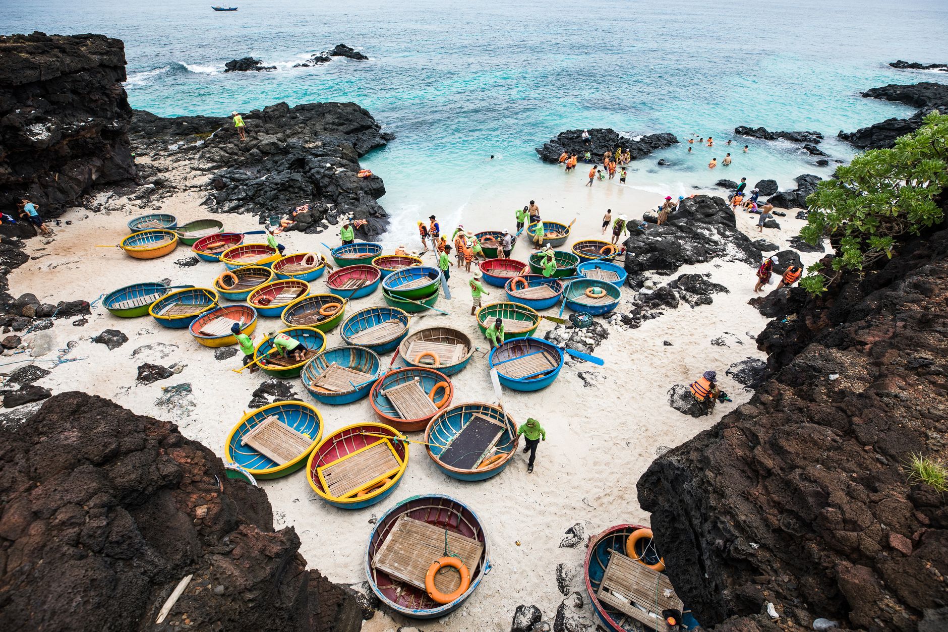
Photo by Son Tung Tran on Pexels
People and Culture
The ethnic composition is largely "Kinh" (ethnic Vietnamese) in the coastal lowlands, over 99%. The southwest is Hre territory; the Xo Dang live in mountain districts like Son Ha; Chams cluster along the southern coast; the Co majority the inland Tra Bong area. This ethnic mosaic is part of why Quang Ngai feels less homogeneous than many coastal provinces.

Photo by Fu Shan Un on Pexels
Economy: From Agriculture to Industry
Rice is the agricultural staple—381,200 tonnes harvested in 2007—with sugar-cane, peanuts, and coconuts as secondary crops. Cattle herds number around 288,000, mostly in the northwest and southwest.
Fishing is substantial. "Ly Son" island offshore is a major fishing center, accounting for almost a quarter of the province's 126,000 tonnes of fish caught in 2012. Ly Son is worth a visit if you want to see a working fishing community without the tourist overlay.
Industry has exploded since 2009. The Dung Quat Economic Zone operates with a separate visa regime for foreign workers and has attracted significant Japanese investment. Industrial output grew 144.7% in 2009 alone. Beer, textiles, bricks, fertilizer, and furniture are produced here. Vinatex, the state textile conglomerate, has expanded into the province. By 2009, industry accounted for 46.3% of GDP—higher than Da Nang (다낭 / 岘港 / ダナン).
This industrial growth matters for travelers: it explains why Quang Ngai City feels busier and more developed than you might expect for a "less developed" province. Roads are decent. Facilities exist. It's not a backpacker backwater.
Why Visit
Quang Ngai offers an unvarnished view of central Vietnam—working fishing villages, mountain ethnic minority settlements, industrial-era coastal towns, and genuine local hospitality. If you're driving National Route 1 between Da Nang and the Mekong Delta (메콩 델타 / 湄公河三角洲 / メコンデルタ), Quang Ngai City and Ly Son island are logical stops. The Thien An pagoda and the Long Wall sites appeal to history-minded travelers. The province is least touristy in its region, which is exactly the appeal.
Going to Vietnam? Eat and travel smarter.
Monthly: new dishes, off-the-beaten-path destinations, and itineraries — straight to your inbox. No spam. Unsubscribe anytime.
Join 0 expats. (We just launched.)
More from Central Vietnam
Other articles covering the same region.

Paradise Cave, Quang Binh: The 31km Marble Cave That Beats Phong Nha for Photographers
Paradise Cave runs 31km through Quang Binh's karst and delivers the kind of cathedral-scale formations that Phong Nha's boat tour simply can't match. Here's how to see it properly.

Son Doong Cave: What the $3,000 Oxalis Expedition Actually Includes
Son Doong is the world's largest cave and only one operator is legally allowed to take you inside. Here is what the permit-only expedition covers and whether it is worth it.

Phong Nha Cave: Wet Cave, Dry Cave, and How to Choose
Phong Nha has two main caves worth your time — one you reach by river boat, one on foot. Here's how to pick, what each costs, and when to go.
More in Destinations
More articles from the same category.

Landmark 81 Saigon: Observation Deck, Ice Rink, and Getting There from District 1
Landmark 81 is Vietnam's tallest building and Saigon's most visible skyline anchor. Here's what's actually inside and whether it's worth the trip.

Bitexco Financial Tower: Skydeck, Helipad Bar, and Whether the Ticket Is Worth It
Saigon's most recognizable skyscraper charges 250,000 VND to ride up to the 49th floor — here's what you actually see, and whether you should bother.

Notre Dame Cathedral Saigon: French Colonial Centerpiece in the Heart of HCMC
Saigon's Notre Dame Cathedral has been wrapped in scaffolding for years, but the square in front of it remains one of the best starting points for a colonial-era walking tour of District 1.

Hoi An Lantern Festival: Full Moon Nights and How to Plan Around Them
Once a month, Hoi An cuts the electricity and lights the Ancient Town with silk lanterns. Here's what actually happens and how to not spend the evening stuck in a crowd.

Japanese Bridge Hoi An: 400 Years of History, a Restoration Row, and How to See It Right
Hoi An's Japanese Bridge has anchored the Ancient Town for four centuries. Here's what to know about its origins, the restoration that divided locals, and when to visit.

Hoi An Old Town Walking Guide: Yellow Walls, Lantern Alleys, and the Japanese Bridge
A street-level route through Hoi An's UNESCO core — old merchant houses, assembly halls, the famous Japanese Bridge, and when to walk each stretch for the best light.
Comments
Loading…