Tay Ninh Province: Rubber Plantations, Cao Dai Temples, and Border Gateway
Tay Ninh province sits 99 km northwest of Ho Chi Minh City, straddling rubber and sugar plantations, the Cao Dai Holy See, and the Moc Bai border crossing into Cambodia. A working agricultural heartland with distinct spiritual culture and surprising depth for a day trip or overnight.

Gateway to Cambodia and the Cao Dai
Tay Ninh province occupies the crossroads between Ho Chi Minh City and Phnom Penh, Cambodia — roughly 99 km from the city center via National Route 22, and 40 km from the Cambodian border. As of 2019, it holds a population of 1.17 million spread across 4,042 km². The province's defining feature is the Cao Dai faith, one of Vietnam (베트남 / 越南 / ベトナム)'s homegrown religions, with its Holy See anchored in Tay Ninh. The other major religious presence is Hoa Hao Buddhism. For travelers, Tay Ninh reads as a working province — not a tourist destination in the classic sense, but a genuine slice of rural Southeast Vietnam that most visitors skip.
The Cao Dai Holy See and Religious Landscape
The Cao Dai Holy See (Caodaism) dominates Tay Ninh's spiritual identity. As of 2019, the province counted 415,920 Cao Dai followers — the largest single religious group. Catholicism (45,992 adherents), Buddhism (38,336), and Islam (3,337) follow. The Cao Dai temple, with its pastel-colored architecture and syncretic iconography blending Confucianism, Buddhism, Christianity, and Daoism, is the primary draw for outsiders.
Tay Ninh is ethnically mixed. The Kinh (ethnic Vietnamese) form the majority at 1.05 million (2009 census). Khmer (7,578), Cham (3,250), ethnic Chinese/Hoa (2,495), and Xtiêng (1,654) round out the population. This ethnic diversity reflects the province's border position and historical role as a frontier.
Agriculture and Landscape
Rubber and sugar dominate the visible landscape. In 2016–2018, Tay Ninh's agricultural strategy pivoted toward higher-value fruit crops — soursop, grapefruit, pineapple, banana, dragon fruit — grown under VietGAP standards. By end of 2018, fruit-growing areas had reached 20,212 hectares with a 9.1% annual growth rate. Rice and cassava still exist but are no longer the economic anchor.
The climate is tropical monsoon: dry season December–April (30–34 °C daytime, cool nights), rainy season May–November (warm, humid, 1,800–2,200 mm annual rainfall). The inland position behind the Truong Son Range offers some typhoon shelter from June to August. This climate suits not only rubber and sugar but also fruit and livestock.
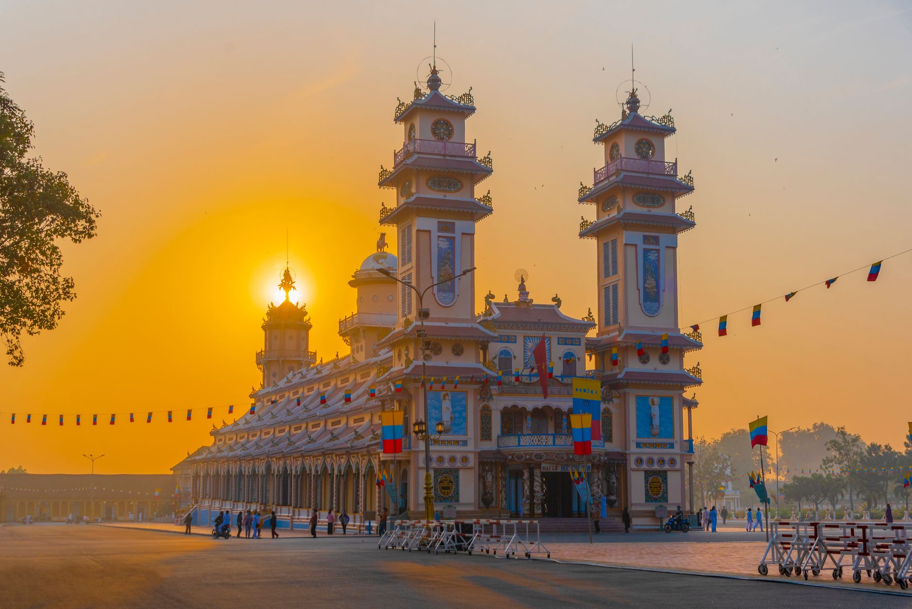
Photo by Thịnh La on Pexels
Festivals and Lunar Calendar
Tay Ninh observes two major festivals tied to Black Virgin Mountain:
- Black Virgin Mountain Festival (15th–18th day, first lunar month): pilgrimage and religious observance
- Via Ba Festival (5th–6th day, fifth lunar month): secondary celebration at the same site
The Hoi Yen Dieu Tri festival at the Cao Dai Holy See occurs on the 15th day of the eighth lunar month. All three are lunar-calendar events; check ahead before visiting.
Infrastructure and Border Access
As of October 2019, a major infrastructure project was greenlit: the Ho Chi Minh City (호치민시 / 胡志明市 / ホーチミン市)–Moc Bai Expressway, a public-private partnership connecting the city to the Moc Bai International Border Gate. National Route 22 currently carries roughly 39,700 vehicles daily (near its 40,000 design capacity) between Ho Chi Minh City and Moc Bai. The new expressway is scheduled for completion by 2025 with at least four lanes, with expansion to six or eight lanes planned by 2045.
Moc Bai International Border Gate facilitates trade and tourism with Cambodia and Thailand. For travelers, this is the key overland crossing if you're heading northwest toward the Cambodian border or onward to Thailand.

Photo by Haneul Trac on Pexels
Economic Profile
Tay Ninh has demonstrated steady growth. In 2018, gross regional domestic product grew 8.5%, and the provincial competitiveness index jumped five places year-on-year, ranking 14th out of 63 Vietnamese cities and provinces. The province operates nine industrial parks (five operational, four planned) covering 4,485 hectares total, with focus on rubber processing, sugar refining, and light manufacturing.
The economy remains rooted in agriculture and border trade. Tay Ninh is not a commercial or tech hub; it is the heartland of rubber, sugar, fruit, and cross-border logistics.
When to Visit
Dry season (December–April) is preferable for travel — cooler, less rain, easier road conditions. The rainy season (May–November) brings mud and humidity but far fewer tourists. Most travelers base themselves in Ho Chi Minh (호치민 / 胡志明 / ホーチミン) City and take a day trip or overnight to see the Cao Dai Holy See and Black Virgin Mountain, then continue to Moc Bai if crossing into Cambodia.
Tay Ninh is not a leisure destination; it is a historical and religious site with genuine agricultural landscape. Come for the temples, the border crossing, and the working Vietnamese countryside — not for beaches or nightlife.
Going to Vietnam? Eat and travel smarter.
Monthly: new dishes, off-the-beaten-path destinations, and itineraries — straight to your inbox. No spam. Unsubscribe anytime.
Join 0 expats. (We just launched.)
More from tay-ninh
Other articles covering this city.

Best Banh Canh in Ho Chi Minh City: Where Locals Send You
Banh canh is thick, chewy, and deeply satisfying—and Ho Chi Minh City does it better than most. Here's where locals actually go.

Best Banh Khot in Ho Chi Minh City: Where Locals Send You
Banh khot—crispy, golden cups of savory goodness—are a southern Vietnam staple. Here's where to find the real deal in Saigon, from family stalls to neighborhood favorites.

Where to Stay in Saigon: District 1 vs District 3 vs District 7
Three neighborhoods, three vibes. Pick District 1 for backpackers and chaos, District 3 for quiet and value, or District 7 for modern expat comfort. Here's how each stacks up.
More from Southern Vietnam
Other articles covering the same region.

3 Days Escaping Saigon: Da Lat and Surrounding Highlands
Leave Saigon behind for Da Lat's cool mountain air, pine forests, and French colonial architecture. This tested itinerary covers transport, where to stay, what to eat, and realistic costs for a long weekend.

5 Days in the Mekong Delta: Beyond Can Tho
Skip the tourist boat tours. This itinerary takes you into smaller canals, family orchards, and riverside towns where most visitors don't go—five days based on routes locals actually use.

Best Muc 1 Nang in Mui Ne: Where Locals Send You
Muc 1 nang—grilled squid stuffed with herbs and meat—reaches its peak in Mui Ne. Here's where locals actually eat it, what to order, and why this coastal town makes it better than anywhere else.
More in Destinations
More articles from the same category.

Son Doong Cave: Inside the $3,000 Oxalis Expedition
Son Doong is the world's largest cave by volume—and the only way in is a 4-day permit-exclusive tour with Oxalis. Here's what you actually get, who should go, and what cheaper caves offer instead.

Phong Nha Cave: Boat Tours, Dry Caves, and How to Choose
Phong Nha-Ke Bang has two main cave experiences: the iconic river boat through Phong Nha Cave itself, and the dry trek into Tien Son. Here's how to pick, what to expect, and when to go.

Hoi An Lantern Festival: Full Moon Nights and How to Plan Around Them
The Hoi An Lantern Festival happens on the 14th lunar day each month. Electricity shuts off, lanterns float on the Thu Bon River, and crowds triple. Here's how to time your visit and actually enjoy it.

Japanese Bridge in Hoi An: What to Know Before You Visit
The 400-year-old Japanese Bridge is Hoi An's most iconic landmark. Here's how to see it properly—and avoid the crowds.

Thien Mu Pagoda in Hue: Seven Stories Above the Perfume River
Hue's most recognizable landmark rises 21 metres above the Perfume River. This is the story behind the tower, how to get there, and when to visit without the tour groups.

Lung Cu Flag Tower: Vietnam's Northernmost Point
The drive to Lung Cu Flag Tower takes you to Vietnam's northernmost point at 1,500 metres. It's a half-day trip from Dong Van with a steep climb, mountain views, and nearby Hmong villages.
Comments
Loading…